IMAGES TAKEN NEAR TO
Ryeford, STONEHOUSE, GL10 3HE
Introduction
This page details the photographs taken nearby to GL10 3HE by members of the Geograph project.
The Geograph project started in 2005 with the aim of publishing, organising and preserving representative images for every square kilometre of Great Britain, Ireland and the Isle of Man.

There are currently over 7.5m images from over14,400 individuals and you can help contribute to the project by visiting https://www.geograph.org.uk
Image Map
Images are licensed for reuse under creativecommons.org/licenses/by-sa/2.0
Notes
- Clicking on the map will re-center to the selected point.
- The higher the marker number, the further away the image location is from the centre of the postcode.
Image Listing (123 Images Found)
Images are licensed for reuse under creativecommons.org/licenses/by-sa/2.0
Image
Details
Distance
1
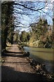
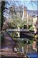
Towpath beside the Stroudwater Canal
Towpath beside the Stroudwater Canal near Ryeford
Image: © Philip Halling
Taken: 30 Jan 2016
0.01 miles
2
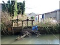
Sluices on the mill stream near Ryeford Mill
Regulating the water levels in the Stroudwater Navigation and the River Frome, to prevent flooding further downstream.
Image: © Christine Johnstone
Taken: 28 Mar 2016
0.02 miles
3
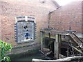
Sluices on the mill stream at Ryeford Mill
The mill stream is fed by the River Frome. Taken through a hedge from the canal towpath.
Image: © Christine Johnstone
Taken: 28 Mar 2016
0.04 miles
4
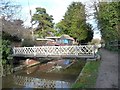
Swingbridge at Ryeford, Stroudwater Navigation
Providing access to houses on the north bank of the canal.
Image: © Christine Johnstone
Taken: 28 Mar 2016
0.04 miles
5
Ryeford Footbridge, Stroudwater Navigation
The swing bridge is reflected in the water of the canal.
Image: © Stephen McKay
Taken: 4 Feb 2022
0.04 miles
6
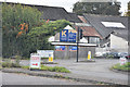
Entrance to Ryeford Industrial estate from A419
Image: © John Firth
Taken: 4 Sep 2017
0.04 miles
7
Stroudwater canal east of Ryeford Road north, Stonehouse
The canal provides a habitat for ducks, coots, moorhens and duckweed, a lot of duckweed. At the right is an industrial estate.
Image: © Brian Robert Marshall
Taken: 21 Aug 2008
0.05 miles
8

Towpath of the Stroudwater Canal
The towpath runs between the csnal and the River Frome. It is also in the course of repairs.
Image: © Bill Boaden
Taken: 17 Jul 2016
0.05 miles
9

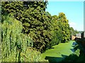
The Thames and Severn Way heading east from Ryeford
The Stroudwater Navigation's towpath is on a narrow strip of land also bordered by part of the River Frome.
Image: © Christine Johnstone
Taken: 28 Mar 2016
0.06 miles
10

Ryeford Double Locks
These are the only staircase locks on the Stroudwater Canal and have quite a colourful history, mainly because they started to fall down not long after they were first constructed! They were designed by a local architect with no known previous canal experience. The canal company then sued him for the repairs however structural failures re-occurred on several subsequent occasions, the most recent being in 1980. In fairness to the original designer though, this last incident was mainly due to failure of an adjoining water main.
The locks have been cleared of overgrowth and debris as restoration gets under way and hopefully modern (re)construction standards will result in a much more stable structure.
Image: © David Stowell
Taken: 9 Jan 2008
0.06 miles