IMAGES TAKEN NEAR TO
Brunel Way, STONEHOUSE, GL10 3GB
Introduction
This page details the photographs taken nearby to Brunel Way, GL10 3GB by members of the Geograph project.
The Geograph project started in 2005 with the aim of publishing, organising and preserving representative images for every square kilometre of Great Britain, Ireland and the Isle of Man.

There are currently over 7.5m images from over14,400 individuals and you can help contribute to the project by visiting https://www.geograph.org.uk
Image Map
Images are licensed for reuse under creativecommons.org/licenses/by-sa/2.0
Notes
- Clicking on the map will re-center to the selected point.
- The higher the marker number, the further away the image location is from the centre of the postcode.
Image Listing (38 Images Found)
Images are licensed for reuse under creativecommons.org/licenses/by-sa/2.0
Image
Details
Distance
1
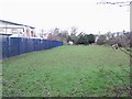
Boundary fence
The great divide between industry and agriculture.
Oldends Farm this side, Oldends industrial estate the other side.
Image: © David Luther Thomas
Taken: 26 Jan 2007
0.05 miles
2
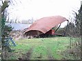
Collapsed barn
A collapsed barn at Oldends Farm. Possibly another casualty of the recent gales.
Image: © David Luther Thomas
Taken: 26 Jan 2007
0.07 miles
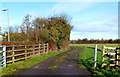
3
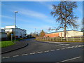
Brunel Way, Stonehouse
Viewed from Oldends Lane.
Image: © Jaggery
Taken: 18 Dec 2011
0.07 miles
4
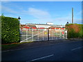
Entrance gates to The Fair Lands, Stonehouse
Viewed across Oldends Lane. The entrance leads into a funfair/amusement park.
Image: © Jaggery
Taken: 18 Dec 2011
0.10 miles
5
Access lane to Oldends Farm, Stonehouse
Viewed from the north side of Oldends Lane.
Image: © Jaggery
Taken: 18 Dec 2011
0.10 miles
6
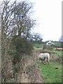
Near Oldends Farm
Looking along the hedge around Oldends Farm, across the fields towards Stagholt Farm.
Image: © David Luther Thomas
Taken: 26 Jan 2007
0.10 miles
7
A funfair Twister, Stonehouse
Located inside The Fair Lands, http://www.geograph.org.uk/photo/3250794 the Twister is a fairground ride that has been popular for decades. One reference source describes the Twister thus: "very fast very smooth and a very popular attraction. Slide to the end and squash your friend!"
Image: © Jaggery
Taken: 18 Dec 2011
0.10 miles
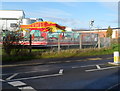
8
The Spa Inn, Stonehouse
Viewed from the edge of Oldends Lane. At the mid-December 2011 date of this view, there was a For Sale notice below the pub sign. http://www.geograph.org.uk/photo/3250749
Image: © Jaggery
Taken: 18 Dec 2011
0.11 miles
9
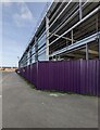
Cheese factory under construction, Stonehouse
Viewed in November 2021. A Stonehouse resident told me that this skeleton of a building is a cheese factory under construction.
Image: © Jaggery
Taken: 7 Nov 2021
0.12 miles
10
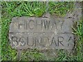
Highway Boundary Marker, Great Oldbury Drive
In the parish of Eastington, near Stonehouse, on the recent development of a large residential estate.
One of several bricks running NW from the bus shelter, at 2.5 m from the kerb, denoting the boundary with open grass.
Image: © Mr Red
Taken: 23 Feb 2024
0.13 miles