1
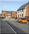
Houses at the SE end of Maurice Shill Close, Great Oldbury
Maurice Shill Close connects with Great Oldbury Drive behind the camera.
Image: © Jaggery
Taken: 7 Nov 2021
0.01 miles
2
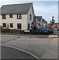
Houses and cars, Maurice Shill Close, Great Oldbury
Maurice Shill Close connects with Great Oldbury Drive behind the camera.
Image: © Jaggery
Taken: 7 Nov 2021
0.02 miles
3
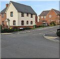
Thomas Tudor Way houses, Great Oldbury
Recently built houses viewed in November 2021.
Image: © Jaggery
Taken: 7 Nov 2021
0.03 miles
4
Junction of Maurice Shill Close and Great Oldbury Drive, Great Oldbury
From the left, Maurice Shill Close joins Great Oldbury Drive.
Image: © Jaggery
Taken: 7 Nov 2021
0.04 miles
5
Northern end of Thomas Tudor Way, Great Oldbury
From the left, Thomas Tudor Way joins Great Oldbury Drive, the main road through Great Oldbury in Gloucestershire.
Image: © Jaggery
Taken: 7 Nov 2021
0.05 miles
6
Bridleway to Westend
Bridleway between Nastend and Westend.
Image: © Philip Halling
Taken: 8 Jun 2015
0.05 miles
7
Junction of James Sleeman Close and Great Oldbury Drive, Great Oldbury
James Sleeman Close descends to Great Oldbury Drive, the main road through the Great Oldbury housing development located between Stonehouse and Eastington in Gloucestershire.
Image: © Jaggery
Taken: 7 Nov 2021
0.06 miles
8
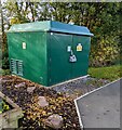
Stonehouse West electricity substation, Great Oldbury, Gloucestershire
Set back from Great Oldbury Drive, the green cabinet is a Western Power Distribution electricity substation. Its identifier is S/S 795880 STONEHOUSE WEST
Image: © Jaggery
Taken: 7 Nov 2021
0.07 miles
9
Community Street Library, Great Oldbury, Gloucestershire
Alongside Great Oldbury Drive near the Alfred Underwood Way junction. The sign shows "Welcome to your Community Street Library. Borrow, swap and donate your books HERE". A dark green electricity substation https://www.geograph.org.uk/photo/7015727 is in the background.
Image: © Jaggery
Taken: 7 Nov 2021
0.07 miles
10
Robert Hulbert Lane, Great Oldbury, Gloucestershire
Viewed from the corner of Great Oldbury Drive in November 2021.
Image: © Jaggery
Taken: 7 Nov 2021
0.08 miles


