IMAGES TAKEN NEAR TO
Duxbury Close, STONEHOUSE, GL10 3FF
Introduction
This page details the photographs taken nearby to Duxbury Close, GL10 3FF by members of the Geograph project.
The Geograph project started in 2005 with the aim of publishing, organising and preserving representative images for every square kilometre of Great Britain, Ireland and the Isle of Man.

There are currently over 7.5m images from over14,400 individuals and you can help contribute to the project by visiting https://www.geograph.org.uk
Image Map
Images are licensed for reuse under creativecommons.org/licenses/by-sa/2.0
Notes
- Clicking on the map will re-center to the selected point.
- The higher the marker number, the further away the image location is from the centre of the postcode.
Image Listing (101 Images Found)
Images are licensed for reuse under creativecommons.org/licenses/by-sa/2.0
Image
Details
Distance
1

Westend bus stop and shelter, Great Oldbury, Gloucestershire
This stop alongside Great Oldbury Drive is for Stagecoach buses to Stroud and to Gloucester.
Image: © Jaggery
Taken: 7 Nov 2021
0.04 miles
2
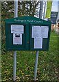
Eastington Parish Council noticeboards
Facing Great Oldbury Drive in Great Oldbury, Gloucestershire.
Image: © Jaggery
Taken: 7 Nov 2021
0.04 miles
3

Thank You For Visiting, Great Oldbury, Gloucestershire
Barratt Homes notice alongside Great Oldbury Drive in November 2021.
Image: © Jaggery
Taken: 7 Nov 2021
0.04 miles
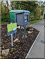
4
Gas installation, Great Oldbury Drive, Great Oldbury
The green cabinet is a Wales & West Utilities gas installation.
Image: © Jaggery
Taken: 7 Nov 2021
0.04 miles
5
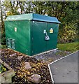
Stonehouse West electricity substation, Great Oldbury, Gloucestershire
Set back from Great Oldbury Drive, the green cabinet is a Western Power Distribution electricity substation. Its identifier is S/S 795880 STONEHOUSE WEST
Image: © Jaggery
Taken: 7 Nov 2021
0.05 miles
6
Community Street Library, Great Oldbury, Gloucestershire
Alongside Great Oldbury Drive near the Alfred Underwood Way junction. The sign shows "Welcome to your Community Street Library. Borrow, swap and donate your books HERE". A dark green electricity substation https://www.geograph.org.uk/photo/7015727 is in the background.
Image: © Jaggery
Taken: 7 Nov 2021
0.05 miles
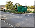
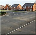
7
BUS ONLY road marking, Great Oldbury Drive, Great Oldbury
Part of the bus turning area near the Alfred Underwood Way junction.
Image: © Jaggery
Taken: 7 Nov 2021
0.05 miles
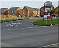
8
Junction of Alfred Underwood Way and Great Oldbury Drive, Great Oldbury
Alfred Underwood Way https://www.geograph.org.uk/photo/7015715 joins Great Oldbury Drive, the main road through the Great Oldbury housing development located between Stonehouse and Eastington in Gloucestershire.
Image: © Jaggery
Taken: 7 Nov 2021
0.05 miles
9
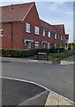
Northwest end of Duxbury Close, Great Oldbury
Great Oldbury Drive housing viewed past the Duxbury Close name sign in November 2021.
Image: © Jaggery
Taken: 7 Nov 2021
0.05 miles
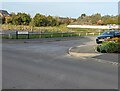
10
Junction of Great Oldbury Drive and Alfred Underwood Way, Great Oldbury
Looking across Great Oldbury Drive towards Alfred Underwood Way houses.
Image: © Jaggery
Taken: 7 Nov 2021
0.06 miles