IMAGES TAKEN NEAR TO
Haresfield, STONEHOUSE, GL10 3ER
Introduction
This page details the photographs taken nearby to GL10 3ER by members of the Geograph project.
The Geograph project started in 2005 with the aim of publishing, organising and preserving representative images for every square kilometre of Great Britain, Ireland and the Isle of Man.

There are currently over 7.5m images from over14,400 individuals and you can help contribute to the project by visiting https://www.geograph.org.uk
Image Map
Images are licensed for reuse under creativecommons.org/licenses/by-sa/2.0
Notes
- Clicking on the map will re-center to the selected point.
- The higher the marker number, the further away the image location is from the centre of the postcode.
Image Listing (3 Images Found)
Images are licensed for reuse under creativecommons.org/licenses/by-sa/2.0
Image
Details
Distance
1
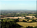
View from Ring Hill.
A beautiful clear day. Looking across the Vale of Gloucester, the Malvern Hills can be seen clearly in the distance (some 30km away). The Vale of Gloucester is the flood plain of the River Severn, and the area was flooded very badly in July this year. In the middle distance is Gloucester itself (the southern side) and in the foreground lots of rich farmland.
Image: © Sharon Loxton
Taken: 9 Sep 2007
0.15 miles
2
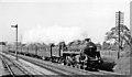
Bristol - Sheffield express near Haresfield, 1960
View southwards on the ex-Midland Birmingham - Bristol main line, with the ex-GW main lines on the left. The locomotive is BR Standard Class 5MT 4-6-0 No. 73016 (built 10/51, withdrawn 12/66).
Image: © Ben Brooksbank
Taken: 30 May 1960
0.20 miles
3
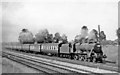
Paignton - Bradford holiday express near Haresfield, 1956
On a peak Summer Saturday the regular 'Devonian' express to/from Bradford/Leeds - Torbay had to have Reliefs, this being the 06.55 Paignton - Bradford, headed by Stanier Class 5 No. 44743, one of the 10 modified examples with Caprotti valve-gear (built 7/48, withdrawn 1/66).
Image: © Ben Brooksbank
Taken: 4 Aug 1956
0.20 miles