IMAGES TAKEN NEAR TO
Haresfield, STONEHOUSE, GL10 3EQ
Introduction
This page details the photographs taken nearby to GL10 3EQ by members of the Geograph project.
The Geograph project started in 2005 with the aim of publishing, organising and preserving representative images for every square kilometre of Great Britain, Ireland and the Isle of Man.

There are currently over 7.5m images from over14,400 individuals and you can help contribute to the project by visiting https://www.geograph.org.uk
Image Map
Images are licensed for reuse under creativecommons.org/licenses/by-sa/2.0
Notes
- Clicking on the map will re-center to the selected point.
- The higher the marker number, the further away the image location is from the centre of the postcode.
Image Listing (56 Images Found)
Images are licensed for reuse under creativecommons.org/licenses/by-sa/2.0
Image
Details
Distance
1
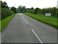
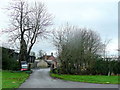
The road into Haresfield, Gloucestershire
The sign marks the edge of the village of Haresfield but the main development is still about 450 metres away on the other side of a railway.
Image: © Brian Robert Marshall
Taken: 30 Aug 2008
0.04 miles
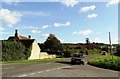
4

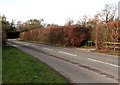
Road junction, north of Haresfield, Gloucestershire
The northern boundary of Haresfield is a few metres behind the viewpoint. The road leading away to the left is signposted for Stonehouse via the B4008.
Image: © Brian Robert Marshall
Taken: 30 Aug 2008
0.07 miles
5
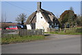
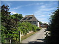
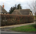
Thatched cottage at Haresfield
Thatched timber-framed cottage in the village of Haresfield.
Image: © Philip Halling
Taken: 2 Mar 2013
0.10 miles
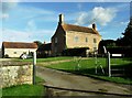
6
Mount Farm, Haresfield
Named after the castle mound directly behind the farm buildings.
Image: © Jonathan Billinger
Taken: 21 Dec 2011
0.10 miles
7
West along Haresfield Lane, Haresfield
Ahead for Hardwicke and Gloucester.
Image: © Jaggery
Taken: 27 Jan 2019
0.10 miles
9
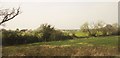
Trees along field boundary, Haresfield
A view from a train on the railway south of Gloucester. On the left are the roof and chimney stacks of The Hollies.
Image: © Derek Harper
Taken: 10 Apr 2015
0.12 miles
10
Thatched roof in Haresfield
On the north side of Haresfield Lane.
Image: © Jaggery
Taken: 27 Jan 2019
0.12 miles