IMAGES TAKEN NEAR TO
Haresfield, STONEHOUSE, GL10 3DZ
Introduction
This page details the photographs taken nearby to GL10 3DZ by members of the Geograph project.
The Geograph project started in 2005 with the aim of publishing, organising and preserving representative images for every square kilometre of Great Britain, Ireland and the Isle of Man.

There are currently over 7.5m images from over14,400 individuals and you can help contribute to the project by visiting https://www.geograph.org.uk
Image Map
Images are licensed for reuse under creativecommons.org/licenses/by-sa/2.0
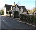
Notes
- Clicking on the map will re-center to the selected point.
- The higher the marker number, the further away the image location is from the centre of the postcode.
Image Listing (67 Images Found)
Images are licensed for reuse under creativecommons.org/licenses/by-sa/2.0
Image
Details
Distance
1
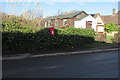
Queen Elizabeth II postbox in a hedge, Haresfield
The village hall https://www.geograph.org.uk/photo/6034532 is on the right.
Image: © Jaggery
Taken: 27 Jan 2019
0.01 miles
2
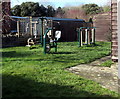
Exercise equipment outside Haresfield Village Hall, Gloucestershire
On the left here. https://www.geograph.org.uk/photo/6034532
Image: © Jaggery
Taken: 27 Jan 2019
0.02 miles
3
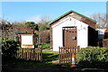
Haresfield Village Hall, Gloucestershire
Viewed in January 2019. All Haresfield Parish Council meetings are held here. Exercise equipment https://www.geograph.org.uk/photo/6034535 has recently been installed on the lawn on the left(SW) side of the hall. No exercise equipment is shown in a September 2016 Google Street View.
Image: © Jaggery
Taken: 27 Jan 2019
0.02 miles
4
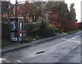
Former BT phonebox, Haresfield
Viewed in January 2019. The telephone equipment has been removed.
Inside the box are an AED (Automated External Defibrillator) and a book bank.
Image: © Jaggery
Taken: 27 Jan 2019
0.02 miles
5
Old Smithy, Haresfield
Two old wagon wheels are embedded in the perimeter wall of the Old Smithy.
Image: © Jaggery
Taken: 27 Jan 2019
0.02 miles
6
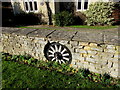
Old wagon wheel in a Haresfield wall
One of two old wheels embedded in the perimeter wall of the Old Smithy. https://www.geograph.org.uk/photo/6034508
Image: © Jaggery
Taken: 27 Jan 2019
0.03 miles
7
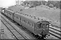
Gloucester - Chalford double-set auto-train near Haresfield, 1956
View NE towards Gloucester, on the four-track Tuffley Junction - Standish Junction joint GW & LMS section. Only on busy Saturdays was it necessary to run two sets together - and as well attach another coach behind the engine, which in this case was Collett 14XX (former 48XX) 0-4-2T no. 1424 (built 11/33 as 4824, renumbered 10/46, withdrawn 12/63)
Image: © Ben Brooksbank
Taken: 16 Jun 1956
0.03 miles
8
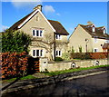
Houses opposite Beacon Lane, Haresfield
Viewed from the western end of Beacon Lane.
Image: © Jaggery
Taken: 27 Jan 2019
0.03 miles
9
Old Post Office, Haresfield
Viewed in January 2019 when the Post Office Branch Finder states that
the nearest post office to Haresfield is in Elm Grove Road East, Hardwicke, Gloucester.
Image: © Jaggery
Taken: 27 Jan 2019
0.04 miles
10
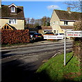
Haresfield Beacon direction sign on a Haresfield corner
On the left here https://www.geograph.org.uk/photo/6034472 the sign points along Beacon Lane towards Haresfield Beacon 1.4 miles (2.2km) away.
Image: © Jaggery
Taken: 27 Jan 2019
0.04 miles