IMAGES TAKEN NEAR TO
Haresfield, STONEHOUSE, GL10 3DX
Introduction
This page details the photographs taken nearby to GL10 3DX by members of the Geograph project.
The Geograph project started in 2005 with the aim of publishing, organising and preserving representative images for every square kilometre of Great Britain, Ireland and the Isle of Man.

There are currently over 7.5m images from over14,400 individuals and you can help contribute to the project by visiting https://www.geograph.org.uk
Image Map
Images are licensed for reuse under creativecommons.org/licenses/by-sa/2.0
Notes
- Clicking on the map will re-center to the selected point.
- The higher the marker number, the further away the image location is from the centre of the postcode.
Image Listing (58 Images Found)
Images are licensed for reuse under creativecommons.org/licenses/by-sa/2.0
Image
Details
Distance
1
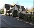
Old Post Office, Haresfield
Viewed in January 2019 when the Post Office Branch Finder states that
the nearest post office to Haresfield is in Elm Grove Road East, Hardwicke, Gloucester.
Image: © Jaggery
Taken: 27 Jan 2019
0.02 miles
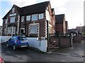
2

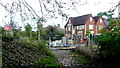
The Beacon Inn
The Beacon Inn at Haresfield. The inn overlooks the Gloucester to Bristol railway line.
Image: © Philip Halling
Taken: 5 Jan 2013
0.02 miles
3
The Beacon & Railway Hotel, Haresfield
Formerly named the Beacon, located near the site of the demolished Haresfield railway station.
The station is seen here https://www.geograph.org.uk/photo/2754421 in 1961.
Image: © Jaggery
Taken: 27 Jan 2019
0.02 miles
4
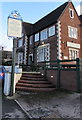
Steps up to The Beacon & Railway Hotel, Haresfield
Formerly named the Beacon, located near the site of the demolished Haresfield railway station.
The station is seen here https://www.geograph.org.uk/photo/2754421 in 1961.
Image: © Jaggery
Taken: 27 Jan 2019
0.02 miles
5
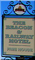
The Beacon & Railway Hotel name sign, Haresfield
Located here. https://www.geograph.org.uk/photo/6034873
Image: © Jaggery
Taken: 27 Jan 2019
0.02 miles
6
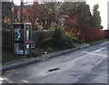
Former BT phonebox, Haresfield
Viewed in January 2019. The telephone equipment has been removed.
Inside the box are an AED (Automated External Defibrillator) and a book bank.
Image: © Jaggery
Taken: 27 Jan 2019
0.02 miles
9
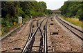
Footpath railway crossing and the Beacon Inn
Not given on OS mapping as a public path, but clearly well used.
Image: © Jonathan Billinger
Taken: 3 Oct 2014
0.03 miles
10
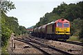
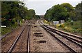
Railway at Haresfield
60063 approaches Haresfield loop with the 05:07 Robeston Sdgs to Westerleigh Murco Tanks. It will wait here for any passenger trains to pass before a clear road down to Westerleigh.
Image: © Stuart Wilding
Taken: 26 Jun 2013
0.04 miles