IMAGES TAKEN NEAR TO
Standish, STONEHOUSE, GL10 3BU
Introduction
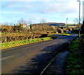
This page details the photographs taken nearby to GL10 3BU by members of the Geograph project.
The Geograph project started in 2005 with the aim of publishing, organising and preserving representative images for every square kilometre of Great Britain, Ireland and the Isle of Man.

There are currently over 7.5m images from over14,400 individuals and you can help contribute to the project by visiting https://www.geograph.org.uk
Image Map
Images are licensed for reuse under creativecommons.org/licenses/by-sa/2.0
Notes
- Clicking on the map will re-center to the selected point.
- The higher the marker number, the further away the image location is from the centre of the postcode.
Image Listing (89 Images Found)
Images are licensed for reuse under creativecommons.org/licenses/by-sa/2.0
Image
Details
Distance
1
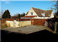
April Cottage, Standish
The cottage is on the north side of Horsemarling Lane.
Image: © Jaggery
Taken: 17 Feb 2013
0.00 miles
2
A view west along Horsemarling Lane, Standish
Looking towards April Cottage. http://www.geograph.org.uk/photo/3336445
Image: © Jaggery
Taken: 17 Feb 2013
0.01 miles
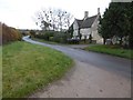
3
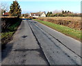
Horsemarling Lane
Horsemarling Lane, winding eastwards from its junction with Gloucester Road.
Image: © David Roberts
Taken: 4 Jul 2010
0.05 miles
4
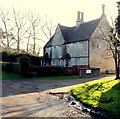
Grade II listed Horsemarling Farmhouse, Standish
Viewed across Horsemarling Lane. The house dates from the 17th century, enlarged in the early 20th century. Grade II listed in December 1986.
Image: © Jaggery
Taken: 17 Feb 2013
0.05 miles
5
Horsemarling Lane near Stonehouse
Horsemarling Lane heads east away from Gloucester Road (the B4008).
Ahead are Horsemarling Farm and Moreton Hill Farm.
Image: © Jaggery
Taken: 18 Dec 2011
0.05 miles
6
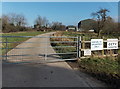
No cold callers at Horsemarling Cottage Farm, Standish
A notice at the entrance from Horesmarling Lane shows VISITORS BY APPOINTMENT ONLY.
Image: © Jaggery
Taken: 17 Feb 2013
0.07 miles
7
Horsemarling Farmhouse
Horsemarling Farmhouse is a Grade II listed building dating from the mid-17th century.
Image: © Philip Halling
Taken: 19 Nov 2016
0.08 miles
8
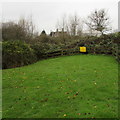
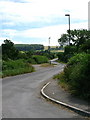
Danger - deep water near Arrowsmith Drive, Stonehouse
The yellow Danger notice is on a fence above an unnamed stream at the northern edge of Stonehouse, near Horsemarling Farm. Viewed from Arrowsmith Drive.
Image: © Jaggery
Taken: 13 Dec 2015
0.10 miles
9
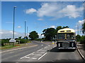
Horsemarling Lane Coach
The junction of Gloucester Road and Horsemarling Lane, by the Standish village sign. The classic Bristol RE coach is making its first run since restoration.
Image: © David Roberts
Taken: 4 Jul 2010
0.11 miles
10
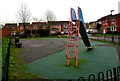
Children's slide, Stonehouse
In a playground on the north side of Arrowsmith Drive.
Image: © Jaggery
Taken: 13 Dec 2015
0.11 miles