IMAGES TAKEN NEAR TO
Bath Road, STONEHOUSE, GL10 3AY
Introduction
This page details the photographs taken nearby to Bath Road, GL10 3AY by members of the Geograph project.
The Geograph project started in 2005 with the aim of publishing, organising and preserving representative images for every square kilometre of Great Britain, Ireland and the Isle of Man.

There are currently over 7.5m images from over14,400 individuals and you can help contribute to the project by visiting https://www.geograph.org.uk
Image Map
Images are licensed for reuse under creativecommons.org/licenses/by-sa/2.0
Notes
- Clicking on the map will re-center to the selected point.
- The higher the marker number, the further away the image location is from the centre of the postcode.
Image Listing (34 Images Found)
Images are licensed for reuse under creativecommons.org/licenses/by-sa/2.0
Image
Details
Distance
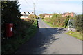
1
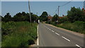
Bath Road
Looking towards Eastington.
Image: © Jonathan Billinger
Taken: 27 Jun 2019
0.02 miles
2
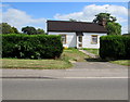
White house, Bath Road, Eastington
Single-storey house set back from the east side of Bath Road.
Image: © Jaggery
Taken: 7 Aug 2016
0.02 miles
3
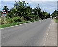
Warning sign - Disabled people, Bath Road, Eastington
The triangular sign is most often used to warn of elderly people nearby. Here the text is Disabled people.
Image: © Jaggery
Taken: 7 Aug 2016
0.02 miles
5
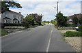
Southern edge of Eastington, Gloucestershire
Looking NNW along Bath Road towards the centre of the village.
Image: © Jaggery
Taken: 7 Aug 2016
0.05 miles
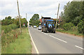
6
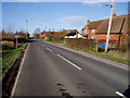
Eastington
The road into the village from Frocester.
Image: © David Gruar
Taken: 23 Jan 2007
0.06 miles
7
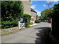
Entrance to Orchard Leigh Camphill Community, Eastington
From Bath Road. The Orchard Leigh Camphill Community website states
"We are a small residential life-sharing community for adults with learning disabilities, providing a supportive social environment to help individuals develop life skills and aim towards independence. We offer work opportunities such as gardening & felt-making and we run a small bakery. Evening activities include drama, bell-ringing and swimming. We work and live out of an anthroposophical ethos. Member of the Association of Camphill Communities in the UK and Ireland."
Image: © Jaggery
Taken: 7 Aug 2016
0.09 miles
8
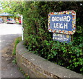
Orchard Leigh Camphill Community name sign, Eastington
Facing Bath Road alongside this https://www.geograph.org.uk/photo/5833331 entrance.
Image: © Jaggery
Taken: 7 Aug 2016
0.09 miles
9
Road from Eastington
A no through road from Eastington to Cress Green.
Image: © Philip Halling
Taken: 29 Oct 2011
0.10 miles
10
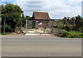
Eastington Pumping Station, Gloucestershire
Severn Trent Water site in a fenced enclosure on the east side of Bath Road.
Image: © Jaggery
Taken: 7 Aug 2016
0.10 miles