IMAGES TAKEN NEAR TO
Bath Road, STONEHOUSE, GL10 3AX
Introduction
This page details the photographs taken nearby to Bath Road, GL10 3AX by members of the Geograph project.
The Geograph project started in 2005 with the aim of publishing, organising and preserving representative images for every square kilometre of Great Britain, Ireland and the Isle of Man.

There are currently over 7.5m images from over14,400 individuals and you can help contribute to the project by visiting https://www.geograph.org.uk
Image Map
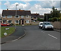
Images are licensed for reuse under creativecommons.org/licenses/by-sa/2.0
Notes
- Clicking on the map will re-center to the selected point.
- The higher the marker number, the further away the image location is from the centre of the postcode.
Image Listing (50 Images Found)
Images are licensed for reuse under creativecommons.org/licenses/by-sa/2.0
Image
Details
Distance
1
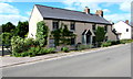
Large cottage in Eastington
On the west side of Bath Road.
Image: © Jaggery
Taken: 7 Aug 2016
0.02 miles
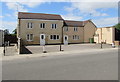
2
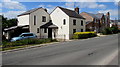
Bath Road houses, Eastington
Eastington is a village and civil parish in Gloucestershire, 7km west of Stroud and 14km south of Gloucester.
There is another Eastington in Gloucestershire - a hamlet near Northleach and Cirencester.
Image: © Jaggery
Taken: 7 Aug 2016
0.02 miles
3
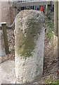
Old Milestone by Bath Road, Eastington
Carved stone post by the UC road, in parish of EASTINGTON (STROUD District), Bath Road, by Pump Cottage, next to garage, on East side of road. Frocester plate, erected by the Frocester (Division) turnpike trust in the 19th century.
Inscription once read:-
(Gloucester 10)
(Tetbury 12)
(Uley 4½)
(from old maps)
Milestone Society National ID: GL_TBGL12.
Image: © C Minto
Taken: 22 Oct 2007
0.03 miles
4
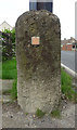
Old milestone, Bath Rd, Eastington
Pump Cottage, next to garage, on East side of road. Frocester plate, erected by the Frocester (Division) turnpike trust in the 19th century.
The current owners moved it from a position about 10m SSE of current location, when they demolished the cycle shop in front of the cottage. Old BM not visible, 85.8 ft ASL. More milestones in the area see http://umap.openstreetmap.fr/en/map/stonehouse-milestones_519080#14/51.7521/-2.2960
Inscription once read:- : (Gloucester 10 / Tetbury 12 / Uley 4½) : (from old maps) or Uley 4½ - depending on year.
Listed.
Milestone Society National ID: GL_TBGL12
Image: © Mr Red
Taken: 4 Sep 2020
0.03 miles
5
Bath Road semis, Eastington
Semi-detached houses on the west side of Bath Road, immediately north of Bath Road Garage. https://www.geograph.org.uk/photo/5833214
Image: © Jaggery
Taken: 7 Aug 2016
0.03 miles
6
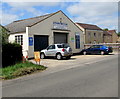
Bath Road Garage, Eastington
In August 2017 the nameboard shows servicing, repairs, MOT & sales.
Image: © Jaggery
Taken: 7 Aug 2016
0.05 miles
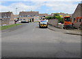
7
Swallowcroft, a housing estate in Eastington
Image: © David Smith
Taken: 8 Jun 2018
0.06 miles
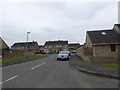
8
Swallow Croft, Eastington
Cul-de-sac viewed across Bath Road.
Image: © Jaggery
Taken: 7 Aug 2016
0.07 miles
9
Western end of Swallowcroft, Eastington
Viewed across Bath Road. A hubcap rests on the street name sign.
Image: © Jaggery
Taken: 29 Jun 2014
0.07 miles
10
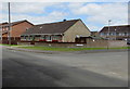
Bungalows near an Eastington corner, Gloucestershire
On the Bath Road side of the Swallow Croft corner. Originally, bungalow was used in English for a lightly-built house, with a veranda and one storey. In current UK usage it is a convenient word for any one-storey dwelling.
Image: © Jaggery
Taken: 7 Aug 2016
0.08 miles