IMAGES TAKEN NEAR TO
Severn Terrace, Severn Road, STONEHOUSE, GL10 2RW
Introduction
This page details the photographs taken nearby to Severn Terrace, Severn Road, GL10 2RW by members of the Geograph project.
The Geograph project started in 2005 with the aim of publishing, organising and preserving representative images for every square kilometre of Great Britain, Ireland and the Isle of Man.

There are currently over 7.5m images from over14,400 individuals and you can help contribute to the project by visiting https://www.geograph.org.uk
Image Map
Images are licensed for reuse under creativecommons.org/licenses/by-sa/2.0
Notes
- Clicking on the map will re-center to the selected point.
- The higher the marker number, the further away the image location is from the centre of the postcode.
Image Listing (119 Images Found)
Images are licensed for reuse under creativecommons.org/licenses/by-sa/2.0
Image
Details
Distance
1
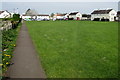
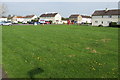
Path past the edge of a green in Stonehouse
The path extends from Park Road to Severn Road.
Image: © Jaggery
Taken: 22 Apr 2018
0.03 miles
2
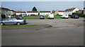
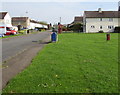
Parking area on the west side of Severn Road, Stonehouse
Midland Road houses in the background are behind a small green.
Image: © Jaggery
Taken: 22 Apr 2018
0.04 miles
3
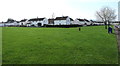
White and green in Stonehouse
From Severn Road looking across a green towards white houses.
Image: © Jaggery
Taken: 22 Apr 2018
0.04 miles
4
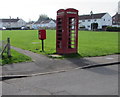
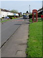
Red corner of a green, Severn Road, Stonehouse
Red phonebox and red postbox on the NW corner of a green extending to Park Road.
Image: © Jaggery
Taken: 22 Apr 2018
0.06 miles
5
Across a green in Stonehouse
From this https://www.geograph.org.uk/photo/6428563 path looking NW towards a red phonebox and postbox.
Image: © Jaggery
Taken: 22 Apr 2018
0.06 miles
6
Green on the east side of Severn Road, Stonehouse
Beyond the right edge of the photo, the green extends eastwards to Park Road.
Image: © Jaggery
Taken: 22 Apr 2018
0.06 miles
7
Pavement towards a red phonebox and postbox, Stonehouse
On the east side of Severn Road. https://www.geograph.org.uk/photo/5754530 to a closer view of the red objects.
Image: © Jaggery
Taken: 22 Apr 2018
0.06 miles
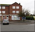
8
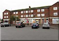
Spar, Park Parade Shops, Stonehouse
Spar store viewed across Park Road in mid December 2015.
An August 2010 Google Earth Street View shows a Londis store here.
Image: © Jaggery
Taken: 13 Dec 2015
0.06 miles
9
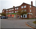
Park Parade shops, Stonehouse
Viewed across Park Road. The large shop in the middle is a Londis convenience store.
Image: © Jaggery
Taken: 20 Nov 2011
0.07 miles
10
All Pulling Together, Stonehouse
Community Association located at the northern end of Park Parade Shops, Park Road.
Image: © Jaggery
Taken: 13 Dec 2015
0.07 miles