IMAGES TAKEN NEAR TO
Orchard Court, STONEHOUSE, GL10 2QP
Introduction
This page details the photographs taken nearby to Orchard Court, GL10 2QP by members of the Geograph project.
The Geograph project started in 2005 with the aim of publishing, organising and preserving representative images for every square kilometre of Great Britain, Ireland and the Isle of Man.

There are currently over 7.5m images from over14,400 individuals and you can help contribute to the project by visiting https://www.geograph.org.uk
Image Map
Images are licensed for reuse under creativecommons.org/licenses/by-sa/2.0
Notes
- Clicking on the map will re-center to the selected point.
- The higher the marker number, the further away the image location is from the centre of the postcode.
Image Listing (916 Images Found)
Images are licensed for reuse under creativecommons.org/licenses/by-sa/2.0
Image
Details
Distance
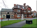
1
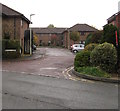
Orchard Court, Stonehouse
Cul-de-sac on the northwest side of Laburnum Walk.
Image: © Jaggery
Taken: 3 Nov 2019
0.02 miles
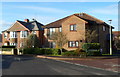
2
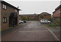
Orchard Court housing, Stonehouse
Cul-de-sac on the northwest side of Laburnum Walk.
Image: © Jaggery
Taken: 3 Nov 2019
0.03 miles
3
Orchard Place, Stonehouse
From the west side of High Street, Orchard Place leads to Orchard Court.
Image: © Jaggery
Taken: 16 Sep 2018
0.04 miles
4
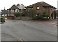
Laburnum Walk houses in Stonehouse
A No Through Road sign is on the left.
Image: © Jaggery
Taken: 3 Nov 2019
0.04 miles
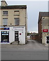
5
Pharmacy and medical centre, Stonehouse
Located side-by-side on the east side of High Street are Stonehouse Pharmacy on the left, and High Street Medical Centre on the right.
Image: © Jaggery
Taken: 20 Nov 2011
0.04 miles
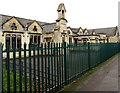
6

Bell tower of the former National School, Stonehouse
The inscription in stone on the bell tower records that the National School was erected in 1832, enlarged in 1873. The building is now part of Park Infant School.
Image: © Jaggery
Taken: 13 Dec 2015
0.04 miles
7
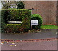
Orchard Court name sign in a hedge, Stonehouse
Next to a notice stating Residents Parking Only - Clamping in progress.
Image: © Jaggery
Taken: 3 Nov 2019
0.04 miles
8
Laburnum Walk, Stonehouse
Viewed from the opposite the corner of Orchard Court on the west side of High Street.
Image: © Jaggery
Taken: 18 Dec 2011
0.05 miles
9
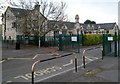
Entrance to The Park Junior School, Stonehouse
Viewed from Elm Road. This entrance also leads to The Park Infants School.
Image: © Jaggery
Taken: 20 Nov 2011
0.05 miles
10
Former National School, Stonehouse
The building is now part of Park Infant School, viewed from a public footpath south of Elm Road.
The inscription on the bell tower http://www.geograph.org.uk/photo/5051533 records that the National School was erected in 1832, enlarged in 1873.
Image: © Jaggery
Taken: 13 Dec 2015
0.05 miles