IMAGES TAKEN NEAR TO
Anderson Drive, STONEHOUSE, GL10 2QL
Introduction
This page details the photographs taken nearby to Anderson Drive, GL10 2QL by members of the Geograph project.
The Geograph project started in 2005 with the aim of publishing, organising and preserving representative images for every square kilometre of Great Britain, Ireland and the Isle of Man.

There are currently over 7.5m images from over14,400 individuals and you can help contribute to the project by visiting https://www.geograph.org.uk
Image Map
Images are licensed for reuse under creativecommons.org/licenses/by-sa/2.0
Notes
- Clicking on the map will re-center to the selected point.
- The higher the marker number, the further away the image location is from the centre of the postcode.
Image Listing (533 Images Found)
Images are licensed for reuse under creativecommons.org/licenses/by-sa/2.0
Image
Details
Distance
1
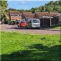
Cars and houses, Anderson Drive, Stonehouse
This Stonehouse is in Gloucestershire.
Image: © Jaggery
Taken: 30 Jul 2023
0.01 miles
2
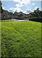
Houses beyond a green, Stonehouse, Gloucestershire
Looking towards houses in Anderson Drive.
Image: © Jaggery
Taken: 30 Jul 2023
0.01 miles
3
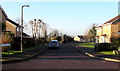
Anderson Drive, Stonehouse
Cul-de-sac viewed across Rosedale Avenue.
Image: © Jaggery
Taken: 28 Dec 2014
0.03 miles
4
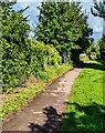
WNW along a path parallel with railway lines, Stonehouse
Ahead for Stonehouse railway station.
Image: © Jaggery
Taken: 30 Jul 2023
0.04 miles
5

Walkers' level crossing near Stonehouse railway station
The level crossing for walkers only (no cyclists) connects Burdett Close on this side with steps up to Anderson Drive ahead. The crossing is less than 200 metres SE of Stonehouse railway station.
Image: © Jaggery
Taken: 28 Dec 2014
0.04 miles
6

Stile to steps down to a level crossing near Stonehouse railway station
This is the Anderson Way side of a level crossing http://www.geograph.org.uk/photo/4292942 for walkers only (no cycling) to Burdett Close across railway lines less than 200 metres SE of Stonehouse railway station.
Image: © Jaggery
Taken: 28 Dec 2014
0.04 miles
7
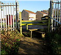
Stile to Anderson Drive, Stonehouse
The stile is at the top of steps up from this http://www.geograph.org.uk/photo/4292942 level crossing for walkers.
Image: © Jaggery
Taken: 28 Dec 2014
0.04 miles
8
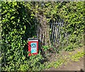
When did you last worm your dog? Stonehouse
The question is on a dog waste bin at the edge of a path.
Image: © Jaggery
Taken: 30 Jul 2023
0.04 miles
9
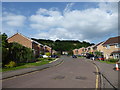
Rosedale Avenue, Stonehouse
New houses close to the station.
Image: © Vieve Forward
Taken: 10 Jun 2018
0.04 miles
10
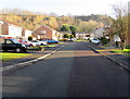
Rosedale Avenue east of Oak Way, Stonehouse
Viewed from the Oak Way junction. http://www.geograph.org.uk/photo/4292629
Image: © Jaggery
Taken: 28 Dec 2014
0.04 miles