IMAGES TAKEN NEAR TO
Ryelands Road, STONEHOUSE, GL10 2PG
Introduction
This page details the photographs taken nearby to Ryelands Road, GL10 2PG by members of the Geograph project.
The Geograph project started in 2005 with the aim of publishing, organising and preserving representative images for every square kilometre of Great Britain, Ireland and the Isle of Man.

There are currently over 7.5m images from over14,400 individuals and you can help contribute to the project by visiting https://www.geograph.org.uk
Image Map
Images are licensed for reuse under creativecommons.org/licenses/by-sa/2.0
Notes
- Clicking on the map will re-center to the selected point.
- The higher the marker number, the further away the image location is from the centre of the postcode.
Image Listing (418 Images Found)
Images are licensed for reuse under creativecommons.org/licenses/by-sa/2.0
Image
Details
Distance
1
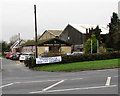
Stonehouse Baptist Church
Stonehouse Baptist Church dates its origins to the early 1900s. Its original building, in Woodcock Lane, was often referred to informally as a tin tabernacle. The current building, seen here, has been the church's location since 1970. It is set back 25 metres from the west side of Gloucester Road.
Image: © Jaggery
Taken: 18 Dec 2011
0.08 miles
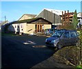
2
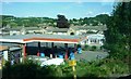
Stonehouse Autoparts, Stonehouse
At 2 Gloucester Road, part of Bridge Service Station. http://www.geograph.org.uk/photo/4785378
The service station shop is on the right.
Image: © Jaggery
Taken: 13 Dec 2015
0.08 miles
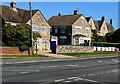
3

Grade II listed houses, Gloucester Road, Stonehouse
Dating from the mid 17th century, with later additions, 10 and 12 Gloucester Road were Grade II listed in 1960.
Image: © Jaggery
Taken: 13 Dec 2015
0.08 miles
4

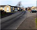
Gloucester Road houses, Stonehouse
On the west side of the B4008 Gloucester Road, viewed from the corner of Meadow Road.
Image: © Jaggery
Taken: 13 Dec 2015
0.08 miles
5
Gloucester Road houses, Stonehouse
Houses alongside the B4008 Gloucester Road viewed from the corner of Meadow Road.
Image: © Jaggery
Taken: 4 Jun 2023
0.08 miles
6
Into the shadows, Gloucester Road, Stonehouse
Viewed across the B4008 on a gloomy, rainy day in December 2020.
A small Londis shop is part of Bridge Service Station at 2 Gloucester Road.
An InstaVolt electric vehicle charging point https://www.geograph.org.uk/photo/6701607 is on the right.
Image: © Jaggery
Taken: 6 Dec 2020
0.08 miles
7
Stonehouse Baptist Church
Stonehouse Baptist Church dates its origins to the early 1900s. Its original building, in Woodcock Lane, was often referred to informally as a tin tabernacle. The current building, seen here, has been the church's location since 1970. It is set back 25 metres from the west side of Gloucester Road.
Image: © Jaggery
Taken: 13 Dec 2015
0.08 miles
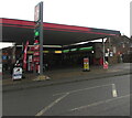
8
Esso Garage and Gloucester Road by John Kerry & Sons
Housing estate is pictured behind Gloucester Road near to the Esso Garage and John Kerry and Sons (visible in foreground). Taken from train en route between Stonehouse and Gloucester.
Image: © Clint Mann
Taken: 4 Aug 2014
0.09 miles
9
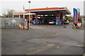
Esso filling station, Stonehouse
The main part of Bridge Service Station at 2 Gloucester Road, immediately north of this http://www.geograph.org.uk/photo/4784797 railway bridge.
Image: © Jaggery
Taken: 13 Dec 2015
0.09 miles
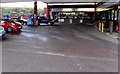
10
Western end of Meadow Road, Stonehouse
Looking past the left turn into Chestnut Avenue, towards Gloucester Road.
Image: © Jaggery
Taken: 17 Feb 2013
0.09 miles