
IMAGES TAKEN NEAR TO
Lyndian Court, Oldends Lane, STONEHOUSE, GL10 2PF
Introduction
This page details the photographs taken nearby to Lyndian Court, Oldends Lane, GL10 2PF by members of the Geograph project.
The Geograph project started in 2005 with the aim of publishing, organising and preserving representative images for every square kilometre of Great Britain, Ireland and the Isle of Man.

There are currently over 7.5m images from over14,400 individuals and you can help contribute to the project by visiting https://www.geograph.org.uk
Image Map
Images are licensed for reuse under creativecommons.org/licenses/by-sa/2.0
Notes
- Clicking on the map will re-center to the selected point.
- The higher the marker number, the further away the image location is from the centre of the postcode.
Image Listing (292 Images Found)
Images are licensed for reuse under creativecommons.org/licenses/by-sa/2.0
Image
Details
Distance
1

Lyndian Court, Stonehouse
Housing viewed across Oldends Lane. The name LYNDIAN COURT is on both sides of the corner.
Image: © Jaggery
Taken: 22 Apr 2018
0.01 miles
2

Oldends Lane warning sign - humps ahead, Stonehouse
The sign is alongside the hedge at the southern perimeter of the St Joseph's Catholic Church site on the corner of Gloucester Road. Vehicles turning right ahead will encounter humps across the road for 210 yards.
Image: © Jaggery
Taken: 13 Dec 2015
0.02 miles
3

Junction of Oldends Lane and Gloucester Road, Stonehouse
Looking west along Oldends Lane across the B4008 Gloucester Road.
A corner of St Joseph's Catholic Church http://www.geograph.org.uk/photo/3250446 is on the right.
Image: © Jaggery
Taken: 13 Dec 2015
0.02 miles
4
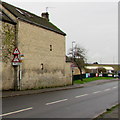
Oldends Lane warning signs, Stonehouse
Facing the Gloucester Road junction, the nearer signs alongside a bus stop sign show a 4.0m (13' 3")
headroom bridge 170 yards ahead. The sign at the corner of the building warns of a school ahead.
Image: © Jaggery
Taken: 13 Dec 2015
0.02 miles
5

Oldends Lane house construction site, Stonehouse
Viewed on January 22nd 2017 from near the corner of Gloucester Road.
The name on the fenced-off site is Campbell South West Ltd (Design & Build).
Image: © Jaggery
Taken: 22 Jan 2017
0.02 miles
6

Timbmet depot, Stonehouse
Located on the west side of Gloucester Road, near the Oldends Lane junction.
Timbmet Depots are part of the Timbmet Group, a UK distributor of hardwoods, panel products and other timber related products. The depots were formed following the Group's acquisition of the established panels businesses of Silverman and Severn Plywood. The depots stock a range of timber panels, hardwood timber, wooden flooring, doors (including flame retardant doors) and decking.
There are also Timbmet depots in Basildon, Borehamwood, Larkfield and Poole.
Image: © Jaggery
Taken: 23 Dec 2012
0.02 miles
7

St. Joseph's RC church, Stonehouse
1960's architecture by Oldends Lane.
Image: © Jonathan Billinger
Taken: 3 Oct 2014
0.02 miles
8

Nice display of geraniums
By the entrance to St. Joseph's RC church.
Image: © Jonathan Billinger
Taken: 3 Oct 2014
0.02 miles
9

Oldends Lane name sign, Stonehouse
At the eastern end of Oldends Lane near the B4008 Gloucester Road junction.
Image: © Jaggery
Taken: 11 May 2025
0.02 miles
10

Southern approach to Oldends Lane, Stonehouse
Viewed from grass on the west side of the B4008 Gloucester Road
looking towards the right turn into Oldends Lane.
Ahead on Gloucester Road for Stonehouse town centre.
Image: © Jaggery
Taken: 11 May 2025
0.02 miles