IMAGES TAKEN NEAR TO
The Lawns, High Street, STONEHOUSE, GL10 2NU
Introduction
This page details the photographs taken nearby to The Lawns, High Street, GL10 2NU by members of the Geograph project.
The Geograph project started in 2005 with the aim of publishing, organising and preserving representative images for every square kilometre of Great Britain, Ireland and the Isle of Man.

There are currently over 7.5m images from over14,400 individuals and you can help contribute to the project by visiting https://www.geograph.org.uk
Image Map
Images are licensed for reuse under creativecommons.org/licenses/by-sa/2.0
Notes
- Clicking on the map will re-center to the selected point.
- The higher the marker number, the further away the image location is from the centre of the postcode.
Image Listing (731 Images Found)
Images are licensed for reuse under creativecommons.org/licenses/by-sa/2.0
Image
Details
Distance
1

The Lawns, Stonehouse
Cul-de-sac extending for 70 metres from the west side of the B4008.
Image: © Jaggery
Taken: 13 Dec 2015
0.02 miles
2
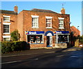
Break charity shop, Stonehouse
Located at 80 High Street.
Image: © Jaggery
Taken: 18 Dec 2011
0.03 miles
3

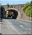
B4008 towards High Street, Stonehouse
Viewed from the edge of the B4008 Gloucester Road looking under this http://www.geograph.org.uk/photo/5052057 railway bridge towards The Lawns junction and the B4008 High Street.
Image: © Jaggery
Taken: 13 Dec 2015
0.03 miles
4
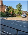
Junction of High Street and The Lawns, Stonehouse, Gloucestershire
Looking across the B4008 High Street towards the cul-de-sac named The Lawns.
Image: © Jaggery
Taken: 4 Jun 2023
0.03 miles
5
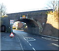
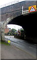
High Street/Gloucester Road railway bridge, Stonehouse
Viewed along Gloucester Road. The bridge is located about 450 metres NW of Stonehouse railway station. The tunnel portal on the left leads to a footpath under the bridge to High Street on the far side of the bridge. The triangular sign on the bridge shows that the overhead clearance is 15' 3". The 30mph speed limit zone becomes 20mph ahead. The moveable triangular Flood sign was a mystery. It was a dry, sunny day in mid-December 2011, with no standing water on the road nearby (or elsewhere in the area).
Image: © Jaggery
Taken: 18 Dec 2011
0.03 miles
6

Walking under the Gloucester Road railway bridge, Stonehouse
Two men use the pedestrian underpass on the east side of the railway bridge over the B4008 Gloucester Road.
Image: © Jaggery
Taken: 13 Dec 2015
0.03 miles
7
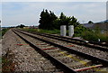
Railway from Stonehouse towards Gloucester
Viewed near this https://www.geograph.org.uk/photo/6190299 level crossing.
Image: © Jaggery
Taken: 23 Jun 2019
0.03 miles
8
Headroom warning sign on Stonehouse High Street railway bridge
Headroom shown is 15' 3". In December 2020 during the Coronavirus (COVID-19) pandemic, a yellow notice showing 'Prevent the spread' is on the left.
Image: © Jaggery
Taken: 6 Dec 2020
0.03 miles
9
NE side of a railway bridge in the centre of Stonehouse, Gloucestershire
Viewed from Gloucester Road. The bridge identifier is
STONEHOUSE HIGH STREET SWM1 105m 16ch.
High Street is on the opposite side of the bridge.
Image: © Jaggery
Taken: 4 Jun 2023
0.03 miles
10

South side of Gloucester Road railway bridge, Stonehouse
The bridge carries railway lines over the B4008 Gloucester Road c450 metres NW of Stonehouse railway station. Walkers should use the underpass on the right.
Image: © Jaggery
Taken: 13 Dec 2015
0.03 miles