IMAGES TAKEN NEAR TO
Burdett Road, STONEHOUSE, GL10 2JW
Introduction
This page details the photographs taken nearby to Burdett Road, GL10 2JW by members of the Geograph project.
The Geograph project started in 2005 with the aim of publishing, organising and preserving representative images for every square kilometre of Great Britain, Ireland and the Isle of Man.

There are currently over 7.5m images from over14,400 individuals and you can help contribute to the project by visiting https://www.geograph.org.uk
Image Map
Images are licensed for reuse under creativecommons.org/licenses/by-sa/2.0
Notes
- Clicking on the map will re-center to the selected point.
- The higher the marker number, the further away the image location is from the centre of the postcode.
Image Listing (888 Images Found)
Images are licensed for reuse under creativecommons.org/licenses/by-sa/2.0
Image
Details
Distance
1
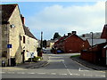
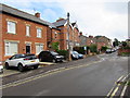
Burdett Road, Stonehouse
Viewed across the B4008 Bath Road. The right turn ahead is into Storrington Road.
Burdett Road also leads to Burdett Close and the main entrance to Stonehouse railway station.
Image: © Jaggery
Taken: 3 Apr 2016
0.01 miles
2
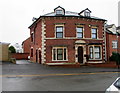
Albion Villa flats near Stonehouse railway station
The Burdett Road building named Albion Villa contains four flats.
Image: © Jaggery
Taken: 22 Dec 2017
0.01 miles
3
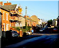
Bright sunshine and deep shadows, Burdett Road, Stonehouse
Except from a small part of the Lizard peninsula in south Cornwall, the British mainland is north of latitude 50 degrees north. This means that the elevation of the midday sun is only about 17 degrees above the horizon in December at latitude 50 north and only 6 or 7 degrees at latitude 60 north.
Thus a day of bright sunshine in December, as here, is also a day of deep shadows.
Image: © Jaggery
Taken: 28 Dec 2014
0.01 miles
4
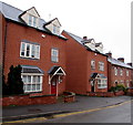
Albion Court, Burdett Road, Stonehouse
Modern houses near Stonehouse railway station.
Image: © Jaggery
Taken: 22 Dec 2017
0.02 miles
5
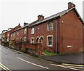
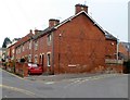
Brick houses, Burdett Road, Stonehouse
The house nearest the camera is on the corner of Storrington Road. https://www.geograph.org.uk/photo/5633466
Image: © Jaggery
Taken: 22 Dec 2017
0.02 miles
6
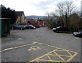
Stonehouse railway station car park
Located on the south side of the station, accessed from Burdett Road (ahead).
The 25 space car park is for railway users only.
Image: © Jaggery
Taken: 23 Mar 2014
0.02 miles
7
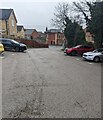
Road south from Stonehouse station, Gloucestershire
Descending to Burdett Road which leads to the B4008 Bath Road.
An entrance to Stonehouse station platform 2 is behind the camera.
Image: © Jaggery
Taken: 2 Apr 2023
0.02 miles
8
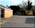
Yellow Faith on the Move vehicle, Stonehouse
Parked behind Bethel Church http://www.geograph.org.uk/photo/4892520 on Sunday April 3rd 2016.
Image: © Jaggery
Taken: 3 Apr 2016
0.03 miles
9
Corner of Storrington Road and Burdett Road, Stonehouse
Burdett Road is on the left.
Image: © Jaggery
Taken: 20 Nov 2011
0.03 miles
10
Cars and houses, Burdett Road, Stonehouse
This part of Burdett Road is between the B4008 Bath Road and the Storrington Road junction ahead.
Image: © Jaggery
Taken: 19 Jul 2020
0.03 miles