IMAGES TAKEN NEAR TO
Storrington Road, STONEHOUSE, GL10 2JP
Introduction
This page details the photographs taken nearby to Storrington Road, GL10 2JP by members of the Geograph project.
The Geograph project started in 2005 with the aim of publishing, organising and preserving representative images for every square kilometre of Great Britain, Ireland and the Isle of Man.

There are currently over 7.5m images from over14,400 individuals and you can help contribute to the project by visiting https://www.geograph.org.uk
Image Map
Images are licensed for reuse under creativecommons.org/licenses/by-sa/2.0
Notes
- Clicking on the map will re-center to the selected point.
- The higher the marker number, the further away the image location is from the centre of the postcode.
Image Listing (705 Images Found)
Images are licensed for reuse under creativecommons.org/licenses/by-sa/2.0
Image
Details
Distance
1
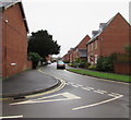
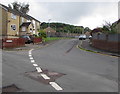
Storrington Road, Stonehouse
Viewed from the corner of Burdett Road. Storrington Road leads to Palmers Court and Springfield Court.
Image: © Jaggery
Taken: 22 Dec 2017
0.03 miles
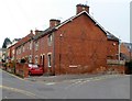
2
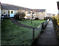
Public footpath past Burdett House, Stonehouse
Built in 1974, Burdett House is retirement/sheltered housing containing 23 flats,
managed by Stroud District Council.
Image: © Jaggery
Taken: 28 Dec 2014
0.04 miles
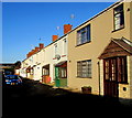
3
East along Storrington Road, Stonehouse
Dead-end road viewed from the Burdett Road junction.
Image: © Jaggery
Taken: 19 Jul 2020
0.04 miles
4
College View, Stonehouse
40 metre long cul-de-sac viewed from the edge of Stonehouse Telephone Exchange. http://www.geograph.org.uk/photo/4302209
Image: © Jaggery
Taken: 28 Dec 2014
0.04 miles
5
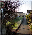
Public footpath from Burdett Close towards Bath Road, Stonehouse
The red-edged circular sign indicates no cycling on this public footpath.
Image: © Jaggery
Taken: 28 Dec 2014
0.04 miles
6
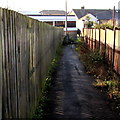
Fenced public footpath towards Bath Road, Stonehouse
Ahead are metal barriers to prevent vehicular misuse
of this public footpath from Burdett Close towards Bath Road.
Image: © Jaggery
Taken: 28 Dec 2014
0.04 miles
8
Black cat, Storrington Road, Stonehouse
Crossing the road near the Burdett Road junction in July 2020.
Image: © Jaggery
Taken: 19 Jul 2020
0.05 miles
9
East along Burdett Close, Stonehouse
Dead-end road viewed from Burdett Road. The railings and wooden fence in the background are alongside the railway near Stonehouse station.
Image: © Jaggery
Taken: 19 Jul 2020
0.05 miles
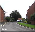
10
Corner of Storrington Road and Burdett Road, Stonehouse
Burdett Road is on the left.
Image: © Jaggery
Taken: 20 Nov 2011
0.05 miles