IMAGES TAKEN NEAR TO
Grosvenor Road, STONEHOUSE, GL10 2HD
Introduction
This page details the photographs taken nearby to Grosvenor Road, GL10 2HD by members of the Geograph project.
The Geograph project started in 2005 with the aim of publishing, organising and preserving representative images for every square kilometre of Great Britain, Ireland and the Isle of Man.

There are currently over 7.5m images from over14,400 individuals and you can help contribute to the project by visiting https://www.geograph.org.uk
Image Map
Images are licensed for reuse under creativecommons.org/licenses/by-sa/2.0
Notes
- Clicking on the map will re-center to the selected point.
- The higher the marker number, the further away the image location is from the centre of the postcode.
Image Listing (155 Images Found)
Images are licensed for reuse under creativecommons.org/licenses/by-sa/2.0
Image
Details
Distance
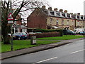
1
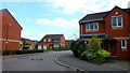
Arrowsmith Drive, Stonehouse
1990's housing on the northern edge of Stonehouse.
Image: © Jonathan Billinger
Taken: 3 Oct 2014
0.03 miles
2
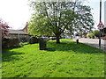
Dark green cabinets on a green in the north of Stonehouse
Dark green telecoms cabinets on the small green on the corner of High Street and Grosvenor Road.
Image: © Jaggery
Taken: 22 Apr 2018
0.04 miles
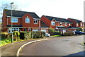
3
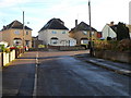
Grosvenor Road houses, Stonehouse
The three houses are at the eastern end of Grosvenor Road where all the houses are detached and have names not numbers. On the right side of the bend is King's Road where the houses are not detached and are numbered.
Image: © Jaggery
Taken: 18 Dec 2011
0.04 miles
4
B4008 Gloucester Road mini-roundabout, Stonehouse
On the west side of Grosvenor Road in the north of Stonehouse.
Image: © Jaggery
Taken: 22 Apr 2018
0.05 miles
5
Warning sign - school, Gloucester Road, Stonehouse
Facing southbound traffic on the B4008 Gloucester Road near Maidenhill School.
Image: © Jaggery
Taken: 13 Dec 2015
0.05 miles
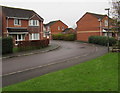
6
Arrowsmith Drive, Stonehouse
This is the Gloucester Road end of Arrowsmith Drive, a long cul-de-sac
of about 140 houses at the northern edge of Stonehouse.
Image: © Jaggery
Taken: 18 Dec 2011
0.06 miles
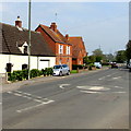
7

Gloucester Road houses opposite Grosvenor Road, Stonehouse
The houses are in the north of Stonehouse, near the Standish boundary.
Image: © Jaggery
Taken: 18 Dec 2011
0.06 miles
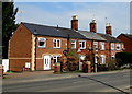
8
90 degree bend in Arrowsmith Drive, Stonehouse
Arrowsmith Drive is an area of about 140 modern houses in northeast Stonehouse.
Image: © Jaggery
Taken: 13 Dec 2015
0.06 miles
9
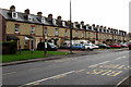
Row of brick houses, Gloucester Road, Stonehouse
Viewed across the B4008. Three of the original five chimneystacks remain in April 2018.
Image: © Jaggery
Taken: 22 Apr 2018
0.06 miles
10
Gloucester Road bus stops, Stonehouse
The stop on the left is for buses to Stroud via High Street Stonehouse.
The stop on the right is for buses to Gloucester.
Image: © Jaggery
Taken: 13 Dec 2015
0.06 miles