IMAGES TAKEN NEAR TO
Kings Road, STONEHOUSE, GL10 2HA
Introduction
This page details the photographs taken nearby to Kings Road, GL10 2HA by members of the Geograph project.
The Geograph project started in 2005 with the aim of publishing, organising and preserving representative images for every square kilometre of Great Britain, Ireland and the Isle of Man.

There are currently over 7.5m images from over14,400 individuals and you can help contribute to the project by visiting https://www.geograph.org.uk
Image Map
Images are licensed for reuse under creativecommons.org/licenses/by-sa/2.0
Notes
- Clicking on the map will re-center to the selected point.
- The higher the marker number, the further away the image location is from the centre of the postcode.
Image Listing (157 Images Found)
Images are licensed for reuse under creativecommons.org/licenses/by-sa/2.0
Image
Details
Distance
1
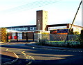
Maidenhill School and Recreation Centre, Stonehouse
Viewed from the corner of King's Road and Woodcock Lane.
Signs show left for the main school entrance, ahead for the sports and dance centre.
Image: © Jaggery
Taken: 18 Dec 2011
0.01 miles
2
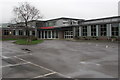
North side of Maidenhill School, Stonehouse
The school website states that Maidenhill School is an 11 to 16 school set at the foot of the Cotswold Hills.
It is a smaller than average secondary school with around 500 students.
It has had a major refurbishment of the main building which was completed in February 2014.
Image: © Jaggery
Taken: 13 Dec 2015
0.01 miles
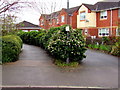
3
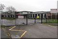
Entrance to Maidenhill, Stonehouse
From King's Road to Maidenhill School, Maidenhill Sports & Dance Centre and Maidenhill Community & Adult Education Centre.
Image: © Jaggery
Taken: 13 Dec 2015
0.03 miles
4
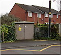
King's Road electricity substation, Stonehouse
The Western Power Distribution electricity substation identifier is KINGS ROAD S/STN 9860.
A notice on the box shows THIEVES BEWARE. SMARTWATER FORENSIC SYSTEMS IN USE.
Image: © Jaggery
Taken: 13 Dec 2015
0.04 miles
5
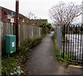
Path past the northern edge of Maidenhill School, Stonehouse
School on the right, Arrowsmith Drive houses on the left. The green bin, numbered 1395, is for dog waste only.
Image: © Jaggery
Taken: 13 Dec 2015
0.04 miles
6
Path from Arrowsmith Drive towards King's Road, Stonehouse
Arrowsmith Drive is an area of about 140 modern houses in northeast Stonehouse.
Image: © Jaggery
Taken: 13 Dec 2015
0.05 miles
7
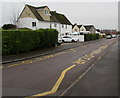
Zigzag yellow lines on King's Road, Stonehouse
Marking a Keep Clear zone on the approach to Maidenhill School.
Image: © Jaggery
Taken: 13 Dec 2015
0.06 miles
8
Christmas tree sale notice, King's Road, Stonehouse
Viewed on December 13th 2015. The notice shows Nordman £35 Norway £20.
Image: © Jaggery
Taken: 13 Dec 2015
0.06 miles
9
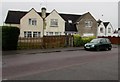
King's Road houses, Stonehouse
On the south side of King's Road, opposite the northern arm of King's Road which leads to Grosvenor Road.
Image: © Jaggery
Taken: 13 Dec 2015
0.07 miles
10
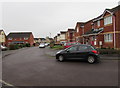
Bend in Arrowsmith Drive, Stonehouse
At the SW edge of Arrowsmith Drive, an area of about 140 modern houses in northeast Stonehouse.
Image: © Jaggery
Taken: 13 Dec 2015
0.08 miles