IMAGES TAKEN NEAR TO
Osprey Drive, STONEHOUSE, GL10 2EG
Introduction
This page details the photographs taken nearby to Osprey Drive, GL10 2EG by members of the Geograph project.
The Geograph project started in 2005 with the aim of publishing, organising and preserving representative images for every square kilometre of Great Britain, Ireland and the Isle of Man.

There are currently over 7.5m images from over14,400 individuals and you can help contribute to the project by visiting https://www.geograph.org.uk
Image Map
Images are licensed for reuse under creativecommons.org/licenses/by-sa/2.0
Notes
- Clicking on the map will re-center to the selected point.
- The higher the marker number, the further away the image location is from the centre of the postcode.
Image Listing (251 Images Found)
Images are licensed for reuse under creativecommons.org/licenses/by-sa/2.0
Image
Details
Distance
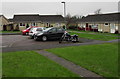
1
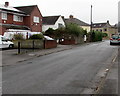
Woodcock Lane, Stonehouse
On the east side of Gloucester Road.
Image: © Jaggery
Taken: 13 Dec 2015
0.05 miles
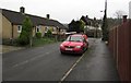
2
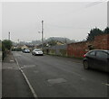
Patched road surface, Woodcock Lane, Stonehouse
Viewed from the corner of the B4008 Gloucester Road in December 2020.
Image: © Jaggery
Taken: 6 Dec 2020
0.07 miles
3
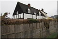
Grade II Listed Bede Cottage, Stonehouse
17th century timber-framed house set back from Greensteet near Sherborne Close.
Grade II listed in 1987.
Image: © Jaggery
Taken: 13 Dec 2015
0.08 miles
4
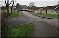
Sherborne Close, Stonehouse
Viewed from the western end of Sherborne Close looking towards Osprey Drive.
Image: © Jaggery
Taken: 13 Dec 2015
0.08 miles
5
Western end of Sherborne Close, Stonehouse
Viewed from a path from Greenstreet.
Image: © Jaggery
Taken: 13 Dec 2015
0.09 miles
6
Red van in Greenstreet, Stonehouse
Greenstreet is a cul-de-sac on the east side of Gloucester Road.
Some references show Green Street, but the name on a nearby sign is Greenstreet.
Image: © Jaggery
Taken: 13 Dec 2015
0.09 miles
7
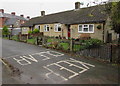
KEEP CLEAR on Greenstreet, Stonehouse
Parking here would block vehicular access to and from the bungalow.
Image: © Jaggery
Taken: 13 Dec 2015
0.09 miles
8
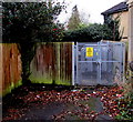
Greenstreet electricity substation, Stonehouse
The Western Power Distribution electricity substation is set back from the south side of Greenstreet.
Image: © Jaggery
Taken: 13 Dec 2015
0.09 miles
9
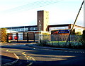
Maidenhill School and Recreation Centre, Stonehouse
Viewed from the corner of King's Road and Woodcock Lane.
Signs show left for the main school entrance, ahead for the sports and dance centre.
Image: © Jaggery
Taken: 18 Dec 2011
0.10 miles
10
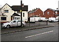
All Done and Dusted vans in Stonehouse
All Done and Dusted Cleaning Services Commercial Ltd vans are parked
behind Woodcock Lane railings near the corner of Gloucester Road.
Image: © Jaggery
Taken: 13 Dec 2015
0.10 miles