IMAGES TAKEN NEAR TO
Midland Road, STONEHOUSE, GL10 2DH
Introduction
This page details the photographs taken nearby to Midland Road, GL10 2DH by members of the Geograph project.
The Geograph project started in 2005 with the aim of publishing, organising and preserving representative images for every square kilometre of Great Britain, Ireland and the Isle of Man.

There are currently over 7.5m images from over14,400 individuals and you can help contribute to the project by visiting https://www.geograph.org.uk
Image Map
Images are licensed for reuse under creativecommons.org/licenses/by-sa/2.0
Notes
- Clicking on the map will re-center to the selected point.
- The higher the marker number, the further away the image location is from the centre of the postcode.
Image Listing (104 Images Found)
Images are licensed for reuse under creativecommons.org/licenses/by-sa/2.0
Image
Details
Distance
1
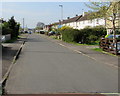
South along Severn Road, Stonehouse
From the Midland Road junction.
Image: © Jaggery
Taken: 22 Apr 2018
0.03 miles
2
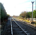
A view south from Oldends Lane level crossing, Stonehouse
Viewed from this http://www.geograph.org.uk/photo/3250640 level crossing. The next station ahead is Cam & Dursley.
Image: © Jaggery
Taken: 18 Dec 2011
0.05 miles
3
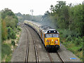
Class 50s in Stonehouse
Class 50 locomotives Nos. 50007 and 50049 double-head the Champion Torbay Express railtour from Eastleigh to Kingswear through Stonehouse after taking over the working at Gloucester.
Image: © Gareth James
Taken: 25 Sep 2021
0.06 miles
4
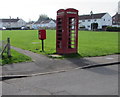
Red corner of a green, Severn Road, Stonehouse
Red phonebox and red postbox on the NW corner of a green extending to Park Road.
Image: © Jaggery
Taken: 22 Apr 2018
0.06 miles
5
Across a green in Stonehouse
From this https://www.geograph.org.uk/photo/6428563 path looking NW towards a red phonebox and postbox.
Image: © Jaggery
Taken: 22 Apr 2018
0.06 miles
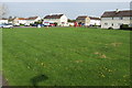
6
Green on the east side of Severn Road, Stonehouse
Beyond the right edge of the photo, the green extends eastwards to Park Road.
Image: © Jaggery
Taken: 22 Apr 2018
0.06 miles
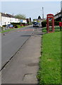
7
Pavement towards a red phonebox and postbox, Stonehouse
On the east side of Severn Road. https://www.geograph.org.uk/photo/5754530 to a closer view of the red objects.
Image: © Jaggery
Taken: 22 Apr 2018
0.06 miles
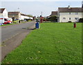
8
Parking area on the west side of Severn Road, Stonehouse
Midland Road houses in the background are behind a small green.
Image: © Jaggery
Taken: 22 Apr 2018
0.06 miles
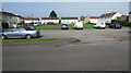
9
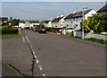
West along Midland Road, Stonehouse
Viewed from the Severn Road junction. The course of Midland Road turns through 90 degrees in the background.
Image: © Jaggery
Taken: 22 Apr 2018
0.06 miles
10
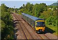
Railway Footbridge
View of the railway line in Stonehouse.
Image: © Wayland Smith
Taken: 8 Jun 2023
0.06 miles