IMAGES TAKEN NEAR TO
Ryeford Road North, STONEHOUSE, GL10 2BU
Introduction
This page details the photographs taken nearby to Ryeford Road North, GL10 2BU by members of the Geograph project.
The Geograph project started in 2005 with the aim of publishing, organising and preserving representative images for every square kilometre of Great Britain, Ireland and the Isle of Man.

There are currently over 7.5m images from over14,400 individuals and you can help contribute to the project by visiting https://www.geograph.org.uk
Image Map
Images are licensed for reuse under creativecommons.org/licenses/by-sa/2.0
Notes
- Clicking on the map will re-center to the selected point.
- The higher the marker number, the further away the image location is from the centre of the postcode.
Image Listing (122 Images Found)
Images are licensed for reuse under creativecommons.org/licenses/by-sa/2.0
Image
Details
Distance
1

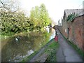
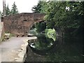
Stroudwater Canal
Ryeford Industrial Estate is on the right, making good use of older industrial premises.
Image: © Bill Boaden
Taken: 17 Jul 2016
0.00 miles
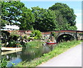
2
The Stroudwater Navigation at Ford's Wharf, Ryeford
Looking eastwards from Ryeford Bridge.
Image: © Christine Johnstone
Taken: 28 Mar 2016
0.01 miles
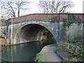
3
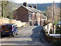
Ryeford Bridge and Spring Cottages
The five terraced cottages were built in 1889, the bridge over the Stroudwater Navigation probably earlier.
Image: © Christine Johnstone
Taken: 28 Mar 2016
0.02 miles
4
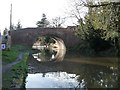
Ryeford Bridge, from the east
Carrying a minor road over the Stroudwater Navigation.
Image: © Christine Johnstone
Taken: 28 Mar 2016
0.02 miles
5
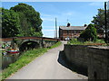
Towpath at Ryeford - Stonehouse, Gloucestershire
A view from the towpath of the Stroudwater Canal, looking eastwards to Ryeford Bridge, between Stroud and Stonehouse. Time taken 2.10 pm BST (British Summer Time).
Image: © Martin Richard Phelan
Taken: 30 Jun 2013
0.02 miles
7
Stroudwater at Ryeford - Stonehouse, Gloucestershire
A view eastwards along the Stroudwater Canal at Ryeford Bridge. In recent years there has been much renovation work done on this waterway by the Cotswold Canals Trust in conjunction with other bodies but what the future might hold is unclear in this present environment of allegedly necessary financial stringency. Time taken 2.09 pm BST (British Summer Time).
Image: © Martin Richard Phelan
Taken: 30 Jun 2013
0.02 miles
8
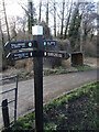
Guidepost where the Cotswold Way meets the canal path
Two long paths meet for a moment at Ryeford Bridge.
Image: © Neil Owen
Taken: 7 Feb 2023
0.02 miles
9
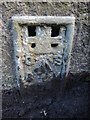
Ryeford Bridge flush bracket
Proving that the ground levels have been higher in the past a concrete pillar and a gas pipe have been removed, leaving the benchmark somewhat dishevelled. See Image] for a wider location view of the bracket numbered 174, and https://www.bench-marks.org.uk/bm9692 for the entry in the Benchmark Database.
Image: © Neil Owen
Taken: 7 Feb 2023
0.02 miles
10
Clearing Ryeford Bridge
Some old things have been cleared from the parapets and walling of the bridge, revealing a benchmark behind the seat that was thought lost. See Image
Image: © Neil Owen
Taken: 7 Feb 2023
0.02 miles