IMAGES TAKEN NEAR TO
Upper Mills Trading Estate, STONEHOUSE, GL10 2BJ
Introduction
This page details the photographs taken nearby to Upper Mills Trading Estate, GL10 2BJ by members of the Geograph project.
The Geograph project started in 2005 with the aim of publishing, organising and preserving representative images for every square kilometre of Great Britain, Ireland and the Isle of Man.

There are currently over 7.5m images from over14,400 individuals and you can help contribute to the project by visiting https://www.geograph.org.uk
Image Map
Images are licensed for reuse under creativecommons.org/licenses/by-sa/2.0
Notes
- Clicking on the map will re-center to the selected point.
- The higher the marker number, the further away the image location is from the centre of the postcode.
Image Listing (157 Images Found)
Images are licensed for reuse under creativecommons.org/licenses/by-sa/2.0
Image
Details
Distance
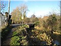
1
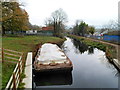
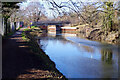
Stroudwater Canal, Upper Mills Industrial Estate, Stonehouse
A view east from a canal bridge near Bristol Road.
Image: © Jaggery
Taken: 20 Nov 2011
0.03 miles
2
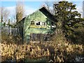
Wycliffe College boathouse
This now derelict timber and corrugated iron structure was once the boat house for the nearby Wycliffe College. This has been replaced by new facilities on the Gloucester and Sharpness Canal. The College's use of this otherwise abandoned length of the Stroudwater Canal helped to preserve it over many years.
Image: © David Stowell
Taken: 9 Jan 2008
0.04 miles
3
Former boathouse of Wycliffe College, Stroudwater Canal
Image: © Vieve Forward
Taken: 22 Apr 2018
0.04 miles
4

Canalside tin shed
A large tin shed in a dilapidated state overlooking the Stroudwater Canal.
Image: © Philip Halling
Taken: 18 Oct 2014
0.05 miles
5
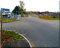
Road to the Stroudwater Canal, Stonehouse
The short road connects a canal bridge ahead with Bristol Road (the A419) behind the camera.
A sign on the left points right for National Cycle Network route 45 to Eastington.
Image: © Jaggery
Taken: 20 Nov 2011
0.05 miles
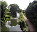
6
Upper Mills Bridge, Stroudwater Navigation
The canal passes round the southern part of Stonehouse, seen here approaching Upper Mills Bridge.
Image: © Stephen McKay
Taken: 4 Feb 2022
0.06 miles
7
East along the Stroudwater Canal, Stonehouse
Viewed from Downton Road.
Image: © Jaggery
Taken: 7 Aug 2016
0.06 miles
8
Whitefield Close Bridgend Stonehouse
On the east side of Downton Road.
Image: © Jaggery
Taken: 7 Aug 2016
0.07 miles
9
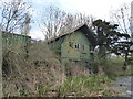
Wycliffe College boathouse
The former Wycliffe College boathouse stands derelict and in a sorry state beside the Stroudwater Canal near Stonehouse. The building has been replaced by a boathouse on the nearby Gloucester and Sharpness Canal.
Image: © Philip Halling
Taken: 30 Jan 2016
0.07 miles
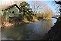
10
Upper Mills Bridge
One of the four swing bridges on the length of the Stroudwater Canal currently under restoration that will need replacement. The existing structure, now fixed, dates back to 1928.
Image: © David Stowell
Taken: 9 Jan 2008
0.08 miles