IMAGES TAKEN NEAR TO
Bridgend Works, STONEHOUSE, GL10 2BA
Introduction
This page details the photographs taken nearby to Bridgend Works, GL10 2BA by members of the Geograph project.
The Geograph project started in 2005 with the aim of publishing, organising and preserving representative images for every square kilometre of Great Britain, Ireland and the Isle of Man.

There are currently over 7.5m images from over14,400 individuals and you can help contribute to the project by visiting https://www.geograph.org.uk
Image Map
Images are licensed for reuse under creativecommons.org/licenses/by-sa/2.0
Notes
- Clicking on the map will re-center to the selected point.
- The higher the marker number, the further away the image location is from the centre of the postcode.
Image Listing (89 Images Found)
Images are licensed for reuse under creativecommons.org/licenses/by-sa/2.0
Image
Details
Distance
1
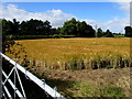
Riverbank track in Bridgend, Stonehouse
Accessed from Downton Road via this kissing gate, https://www.geograph.org.uk/photo/5643471 the track is on a bank of the River Frome.
Image: © Jaggery
Taken: 7 Aug 2016
0.04 miles
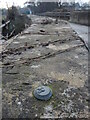
2
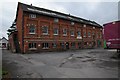
Lower Mills, Bridgend
Former warehouse dating from 1889 by William Clissold.
Image: © Philip Halling
Taken: 18 Oct 2014
0.05 miles
3
West along Haven Avenue, Bridgend, Stonehouse
Towards Crescent Road. The Wharfdale Way junction is on the right.
Image: © Jaggery
Taken: 7 Aug 2016
0.13 miles
4
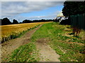
Wires over a Bridgend field, Stonehouse
Viewed from a Downton Road field gate near the Stanley Downton boundary.
Image: © Jaggery
Taken: 7 Aug 2016
0.13 miles
5
Benchmark on Downton Road bridge
A National Rivers Authority bolt benchmark atop the bridge on the outskirts of Stonehouse. This is an earlier version - the latter ones are marked 'EABM', after the organisation changed to the Environment Agency.
Image: © Neil Owen
Taken: 7 Feb 2023
0.14 miles
6
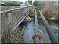
Pipes of Downton Road bridge
Some pipes cross the Frome, Stroud.
Image: © Neil Owen
Taken: 7 Feb 2023
0.14 miles
7
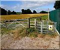
DANGER - Bull in field, Bridgend, Stonehouse
The sign faces Downton Road in the Bridgend area in the south of Stonehouse. Viewed in August 2016.
A metal kissing gate has replaced the wooden stile seen in a July 2009 Google Earth Street View.
Image: © Jaggery
Taken: 7 Aug 2016
0.14 miles
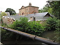
9
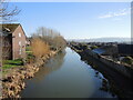
The view from Nutshell Bridge
The Stroudwater Navigation was built in the mid-to-late eighteenth century, providing a link for trade between Gloucester to London, via other canals. Now closed to commercial boats, it has been restored and is run by the Cotswold Canals Trust. As Stonehouse has expanded in recent times some housing is starting to encroach.
Image: © Neil Owen
Taken: 7 Feb 2023
0.15 miles
10
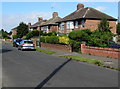
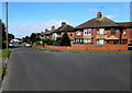
Haven Avenue houses, Bridgend, Stonehouse
Between Wharfdale Way and Crescent Road.
Image: © Jaggery
Taken: 7 Aug 2016
0.16 miles