IMAGES TAKEN NEAR TO
Bridgend, STONEHOUSE, GL10 2AZ
Introduction
This page details the photographs taken nearby to GL10 2AZ by members of the Geograph project.
The Geograph project started in 2005 with the aim of publishing, organising and preserving representative images for every square kilometre of Great Britain, Ireland and the Isle of Man.

There are currently over 7.5m images from over14,400 individuals and you can help contribute to the project by visiting https://www.geograph.org.uk
Image Map
Images are licensed for reuse under creativecommons.org/licenses/by-sa/2.0
Notes
- Clicking on the map will re-center to the selected point.
- The higher the marker number, the further away the image location is from the centre of the postcode.
Image Listing (87 Images Found)
Images are licensed for reuse under creativecommons.org/licenses/by-sa/2.0
Image
Details
Distance
1
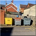
Wheelie bins opposite Stonehouse Health Clinic, Stonehouse
The yellow Tradebe wheelie bin is for medical waste only.
Image: © Jaggery
Taken: 25 Sep 2022
0.06 miles
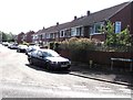
2
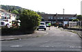
Abbots Way, Bridgend, Stonehouse
Cul-de-sac on the east side of Downton Road in the Bridgend area of Stonehouse.
Image: © Jaggery
Taken: 7 Aug 2016
0.07 miles
3
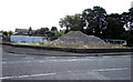
Fenced-off mound of rubble, Bridgend, Stonehouse
The remains of a demolished warehouse on the corner of Abbots Way and Downton Road in the south of Stonehouse.
Image: © Jaggery
Taken: 7 Aug 2016
0.07 miles
4
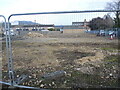
Out of print
A demolition site remains fenced off, presumably awaiting its new use. Previously there was a printers' press here before they moved to Thrupp a few years ago.
Image: © Neil Owen
Taken: 7 Feb 2023
0.07 miles
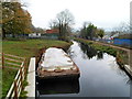
5
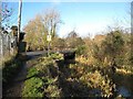
Upper Mills Bridge
One of the four swing bridges on the length of the Stroudwater Canal currently under restoration that will need replacement. The existing structure, now fixed, dates back to 1928.
Image: © David Stowell
Taken: 9 Jan 2008
0.08 miles
6
Whitefield Close Bridgend Stonehouse
On the east side of Downton Road.
Image: © Jaggery
Taken: 7 Aug 2016
0.09 miles
7
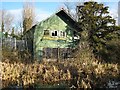
Wycliffe College boathouse
This now derelict timber and corrugated iron structure was once the boat house for the nearby Wycliffe College. This has been replaced by new facilities on the Gloucester and Sharpness Canal. The College's use of this otherwise abandoned length of the Stroudwater Canal helped to preserve it over many years.
Image: © David Stowell
Taken: 9 Jan 2008
0.09 miles
8
Bus stop pole in a hedge, Bridgend, Stonehouse
The Downton Road bus stop near the corner of Haven Avenue is on bus route 66S.
Image: © Jaggery
Taken: 7 Aug 2016
0.10 miles
9
Stroudwater Canal, Upper Mills Industrial Estate, Stonehouse
A view east from a canal bridge near Bristol Road.
Image: © Jaggery
Taken: 20 Nov 2011
0.11 miles
10
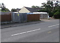
Whitefield Close electricity substation, Bridgend, Stonehouse
Viewed across Downton Road in the Bridgend area of Stonehouse. The Western Power Distribution electricity substation is inside a wooden enclosure near the corner of Whitefield Close. Its identifier is STONEHOUSE WHITEFIELD CLOSE S/S 10220. A caution label on the substation shows the presence of SF6 (sulphur hexafluoride, an insulating gas used in high voltage systems).
Image: © Jaggery
Taken: 7 Aug 2016
0.11 miles