IMAGES TAKEN NEAR TO
Wharfdale Way, STONEHOUSE, GL10 2AQ
Introduction
This page details the photographs taken nearby to Wharfdale Way, GL10 2AQ by members of the Geograph project.
The Geograph project started in 2005 with the aim of publishing, organising and preserving representative images for every square kilometre of Great Britain, Ireland and the Isle of Man.

There are currently over 7.5m images from over14,400 individuals and you can help contribute to the project by visiting https://www.geograph.org.uk
Image Map
Images are licensed for reuse under creativecommons.org/licenses/by-sa/2.0
Notes
- Clicking on the map will re-center to the selected point.
- The higher the marker number, the further away the image location is from the centre of the postcode.
Image Listing (126 Images Found)
Images are licensed for reuse under creativecommons.org/licenses/by-sa/2.0
Image
Details
Distance
1
Houses aligned at right angles to the Stroudwater Canal, Stonehouse
Unlike neighbouring houses http://www.geograph.org.uk/photo/3248935 which face the canal, these Boakes Drive houses are orientated with their sides facing the canal.
Image: © Jaggery
Taken: 20 Nov 2011
0.04 miles
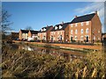
2
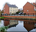
Canalside houses, Stonehouse
Boakes Drive houses viewed across the Stroudwater Canal.
Image: © Jaggery
Taken: 20 Nov 2011
0.04 miles
3
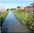
West along the Stroudwater Canal, Stonehouse
Viewed from Downton Road. Boakes Drive houses are on the right.
Image: © Jaggery
Taken: 7 Aug 2016
0.05 miles
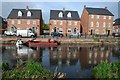
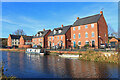
4
Stroudwater Navigation, Stonehouse
Modern three storey houses on Boakes Drive overlook the canal west of Stonehouse Bridge.
Image: © Stephen McKay
Taken: 4 Feb 2022
0.06 miles
5
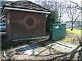
Power and water together
Along Boakes Drive and at the end of the new housing is a small brick electricity substation. Right beside it is a pumping station with underground chambers.
Image: © Neil Owen
Taken: 7 Feb 2023
0.06 miles
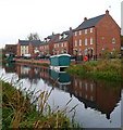
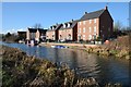
6
Modern housing and the Stroudwater Canal
Modern housing reflected in the Stroudwater Canal near Stonehouse bridge.
Image: © Philip Halling
Taken: 18 Oct 2014
0.06 miles
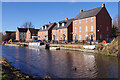
7
Stonehouse Wharf
This former canal and rail wharf area by the Stroudwater Canal has been redeveloped as part of a modern housing estate.
Image: © David Stowell
Taken: 9 Jan 2008
0.06 miles
8
Canalside house, Stonehouse
Canalside house overlooking the Stroudwater Canal near Stonehouse.
Image: © Philip Halling
Taken: 30 Jan 2016
0.07 miles
9
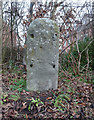
Old Milestone, A419, Stonehouse
Image after setting upright. Currently moved again to private location during 2019 road widening, & pending re-plating and re-setting by the Stonehouse History Group http://stonehousehistorygroup.org.uk . OSGR from old maps, because location was also subject to road widening after the 1965 closure of the Midland Line. More milestones in the area see http://umap.openstreetmap.fr/en/map/stonehouse-milestones_519080#14/51.7521/-2.2960
Stroud 3
Milestone Society National ID: GL_SDGL03
Image: © Mr Red
Taken: 20 Jan 2019
0.07 miles
10
Stroudwater Canal
Canal near Stonehouse, with new housing on Boakes Drive.
Image: © Wayland Smith
Taken: 5 Dec 2020
0.07 miles