IMAGES TAKEN NEAR TO
Crescent Close, STONEHOUSE, GL10 2AP
Introduction
This page details the photographs taken nearby to Crescent Close, GL10 2AP by members of the Geograph project.
The Geograph project started in 2005 with the aim of publishing, organising and preserving representative images for every square kilometre of Great Britain, Ireland and the Isle of Man.

There are currently over 7.5m images from over14,400 individuals and you can help contribute to the project by visiting https://www.geograph.org.uk
Image Map
Images are licensed for reuse under creativecommons.org/licenses/by-sa/2.0
Notes
- Clicking on the map will re-center to the selected point.
- The higher the marker number, the further away the image location is from the centre of the postcode.
Image Listing (149 Images Found)
Images are licensed for reuse under creativecommons.org/licenses/by-sa/2.0
Image
Details
Distance
1
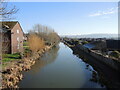
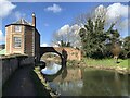
The view from Nutshell Bridge
The Stroudwater Navigation was built in the mid-to-late eighteenth century, providing a link for trade between Gloucester to London, via other canals. Now closed to commercial boats, it has been restored and is run by the Cotswold Canals Trust. As Stonehouse has expanded in recent times some housing is starting to encroach.
Image: © Neil Owen
Taken: 7 Feb 2023
0.04 miles
2
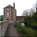
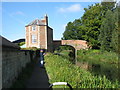
Nutshell House and Nutshell Bridge, Stroudwater Canal, Stonehouse
Nutshell Bridge carries a minor road over the canal south of Bristol Road (the A419).
Grade II listed Nutshell House now in residential use was formerly a warehouse,
built in the 1770s for the owners of the nearby Lower Mills.
Image: © Jaggery
Taken: 20 Nov 2011
0.07 miles
3
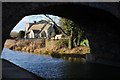
Stonehouse church viewed through a canal bridge
St Cyr's church, Stonehouse, viewed under a bridge over the Stroudwater Canal
Image: © Philip Halling
Taken: 30 Jan 2016
0.07 miles
4
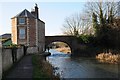
Nutshell House and Nutshell Bridge
Nutshell House and Nutshell Bridge on Stroudwater Canal near Stonehouse.
Image: © Philip Halling
Taken: 30 Jan 2016
0.07 miles
6
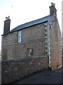
The Nutshell
A large brick house stands right on the bridge approach over the Stroudwater Navigation. By the guardstone is a benchmark of nineteenth century creation - see Image
Image: © Neil Owen
Taken: 7 Feb 2023
0.07 miles
7
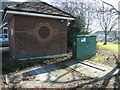
Power and water together
Along Boakes Drive and at the end of the new housing is a small brick electricity substation. Right beside it is a pumping station with underground chambers.
Image: © Neil Owen
Taken: 7 Feb 2023
0.07 miles
8
Nutshell House and Bridge
On the Stroudwater Canal. The lady in the foreground drew our attention to a kingfisher in the trees on the opposite bank. On the occasion when it made an appearance for us, it moved so quickly that I suspect that her attempts to photograph it were unavailing.
Image: © David Purchase
Taken: 19 Sep 2017
0.08 miles
9
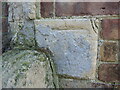
Nutshell bridge benchmark
A cutmark, as listed in the Benchmark Database: https://www.bench-marks.org.uk/bm97329 , on the building that forms part of the canal bridge. See Image] for a wider view.
Image: © Neil Owen
Taken: 7 Feb 2023
0.08 miles
10
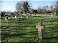
The cemetery by St Cyr's
The church has a long history and graveyard space soon became used. Initially, tombs were located to the south, but as the canal came right past, room was needed elsewhere. After many calls, new land was added in 1908 but that became full in 1960. Over the years more space has been gifted in 1981 and 1997.
Image: © Neil Owen
Taken: 7 Feb 2023
0.09 miles