IMAGES TAKEN NEAR TO
Whitefield Close, STONEHOUSE, GL10 2AL
Introduction
This page details the photographs taken nearby to Whitefield Close, GL10 2AL by members of the Geograph project.
The Geograph project started in 2005 with the aim of publishing, organising and preserving representative images for every square kilometre of Great Britain, Ireland and the Isle of Man.

There are currently over 7.5m images from over14,400 individuals and you can help contribute to the project by visiting https://www.geograph.org.uk
Image Map
Images are licensed for reuse under creativecommons.org/licenses/by-sa/2.0
Notes
- Clicking on the map will re-center to the selected point.
- The higher the marker number, the further away the image location is from the centre of the postcode.
Image Listing (161 Images Found)
Images are licensed for reuse under creativecommons.org/licenses/by-sa/2.0
Image
Details
Distance
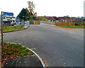
1
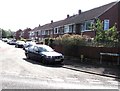
Whitefield Close Bridgend Stonehouse
On the east side of Downton Road.
Image: © Jaggery
Taken: 7 Aug 2016
0.02 miles
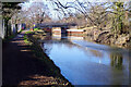
3
East along the Stroudwater Canal, Stonehouse
Viewed from Downton Road.
Image: © Jaggery
Taken: 7 Aug 2016
0.04 miles
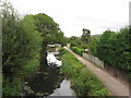
5
Road to the Stroudwater Canal, Stonehouse
The short road connects a canal bridge ahead with Bristol Road (the A419) behind the camera.
A sign on the left points right for National Cycle Network route 45 to Eastington.
Image: © Jaggery
Taken: 20 Nov 2011
0.04 miles
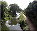
6
Upper Mills Bridge, Stroudwater Navigation
The canal passes round the southern part of Stonehouse, seen here approaching Upper Mills Bridge.
Image: © Stephen McKay
Taken: 4 Feb 2022
0.04 miles
7
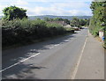
Downton Road, Stonehouse
Downton Road descends from the A419 Bristol Road towards the Bridgend area of Stonehouse.
Image: © Jaggery
Taken: 7 Aug 2016
0.04 miles
8
Looking towards Stonehouse Bridge along the Stroudwater Canal,Stonehouse
A view west from a canal bridge across the Stroudwater Canal, Upper Mills Industrial Estate,
towards Stonehouse Bridge http://www.geograph.org.uk/photo/3248927 which carries Downton Road over the canal.
Image: © Jaggery
Taken: 20 Nov 2011
0.05 miles
9
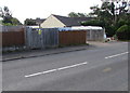
Whitefield Close electricity substation, Bridgend, Stonehouse
Viewed across Downton Road in the Bridgend area of Stonehouse. The Western Power Distribution electricity substation is inside a wooden enclosure near the corner of Whitefield Close. Its identifier is STONEHOUSE WHITEFIELD CLOSE S/S 10220. A caution label on the substation shows the presence of SF6 (sulphur hexafluoride, an insulating gas used in high voltage systems).
Image: © Jaggery
Taken: 7 Aug 2016
0.05 miles
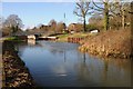
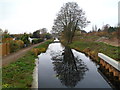
10
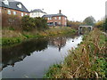
Ducks on the Stroudwater Canal, Stonehouse
A view east towards Stonehouse Bridge. http://www.geograph.org.uk/photo/3248927
Image: © Jaggery
Taken: 20 Nov 2011
0.05 miles