IMAGES TAKEN NEAR TO
Stafford Street West, HELENSBURGH, G84 9PE
Introduction
This page details the photographs taken nearby to Stafford Street West, G84 9PE by members of the Geograph project.
The Geograph project started in 2005 with the aim of publishing, organising and preserving representative images for every square kilometre of Great Britain, Ireland and the Isle of Man.

There are currently over 7.5m images from over14,400 individuals and you can help contribute to the project by visiting https://www.geograph.org.uk
Image Map
Images are licensed for reuse under creativecommons.org/licenses/by-sa/2.0
Notes
- Clicking on the map will re-center to the selected point.
- The higher the marker number, the further away the image location is from the centre of the postcode.
Image Listing (27 Images Found)
Images are licensed for reuse under creativecommons.org/licenses/by-sa/2.0
Image
Details
Distance
1
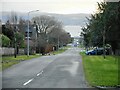
Looking down Suffolk Street
A zoomed view towards the Clyde, taken from beside Millig Street.
Image: © Richard Sutcliffe
Taken: 27 Jan 2022
0.08 miles
2
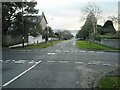
Crossroads
The junction of Suffolk Street and Millig Street.
Image: © Richard Sutcliffe
Taken: 27 Jan 2022
0.09 miles
3
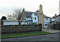
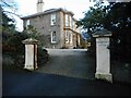
An interesting house on Millig Street
The house dates to 1858 with later additions and is category C listed http://portal.historicenvironment.scot/designation/LB34880.
Image: © Richard Sutcliffe
Taken: 27 Jan 2022
0.09 miles
4
Junction of Queen Street and Suffolk Street, Helensburgh
Image: © David Gearing
Taken: 29 Jul 2011
0.10 miles
5
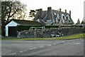
Bedford House
House on Suffolk Street. It dates from about 1860, with later additions and alterations by William Leiper, in 1888 and 1889. From 1898 it was the home of H Bonar Law. It is Category B listed http://portal.historicenvironment.scot/designation/LB34884.
Image: © Richard Sutcliffe
Taken: 27 Jan 2022
0.12 miles
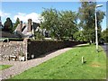
6
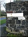
Old and new street nameplates
At the corner of Upper Sutherland Street and Millig Street. The cast iron street nameplate above (for Sutherland St) is still as legible as when it was made (and would be more so if painted). The newer modern street name sign (for Upper Sutherland Street) has faded so much it is almost illegible.
Image: © Richard Sutcliffe
Taken: 27 Jan 2022
0.14 miles
7
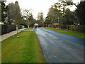
Upper Sutherland Street
Looking towards Millig Street.
Image: © Richard Sutcliffe
Taken: 27 Jan 2022
0.14 miles
8
House on Queen Street
Category C listed house http://portal.historicenvironment.scot/designation/LB34839, by William Leiper, 1898.
Image: © Richard Sutcliffe
Taken: 27 Jan 2022
0.15 miles
9
Villa on Suffolk Street
Category B listed villa http://portal.historicenvironment.scot/designation/LB34881 dating from 1864, built for Charles Hamilton.
Image: © Richard Sutcliffe
Taken: 27 Jan 2022
0.15 miles
10
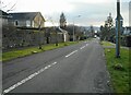
John Street
Looking south from the junction with Queen Street.
Image: © Richard Sutcliffe
Taken: 27 Jan 2022
0.17 miles