IMAGES TAKEN NEAR TO
John Street, HELENSBURGH, G84 9LZ
Introduction
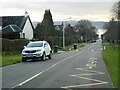
This page details the photographs taken nearby to John Street, G84 9LZ by members of the Geograph project.
The Geograph project started in 2005 with the aim of publishing, organising and preserving representative images for every square kilometre of Great Britain, Ireland and the Isle of Man.

There are currently over 7.5m images from over14,400 individuals and you can help contribute to the project by visiting https://www.geograph.org.uk
Image Map
Images are licensed for reuse under creativecommons.org/licenses/by-sa/2.0
Notes
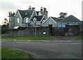
- Clicking on the map will re-center to the selected point.
- The higher the marker number, the further away the image location is from the centre of the postcode.
Image Listing (42 Images Found)
Images are licensed for reuse under creativecommons.org/licenses/by-sa/2.0
Image
Details
Distance
1
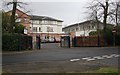
Entrance to Lomond Secondary School
Image: © Richard Sutcliffe
Taken: 1 Mar 2019
0.02 miles
2
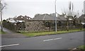
An interesting wall on John Street, Helensburgh
A narrow building is shown on this corner on 19th and early 20th century maps, but seems to have been demolished some time between the 1940s and 1960s. The area it covered is now partly occupied by a bungalow. What remains is an ashlar wall with what appear to have been a filled in window and three sets of three ventilation slots. These have been infilled on the other side.
Image: © Richard Sutcliffe
Taken: 1 Mar 2019
0.08 miles
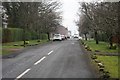
3
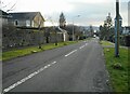
John Street
Looking south from the junction with Queen Street.
Image: © Richard Sutcliffe
Taken: 27 Jan 2022
0.10 miles
4
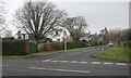
James Street, Helensburgh
At the junction with West Montrose Street.
Image: © Richard Sutcliffe
Taken: 1 Mar 2019
0.11 miles
5
James Street
Looking south towards the Clyde.
Image: © Richard Sutcliffe
Taken: 27 Jan 2022
0.11 miles
6
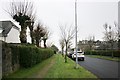
Pollarded trees
On John Street, Helensburgh.
Image: © Richard Sutcliffe
Taken: 1 Mar 2019
0.13 miles
7
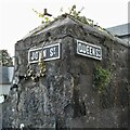
Street names
Cast iron street nameplates on a wall at the corner of John Street and Queen Street. Still as legible as when they were made, they are much better than nearby modern street name signs which have faded so much they are illegible.
Image: © Richard Sutcliffe
Taken: 27 Jan 2022
0.14 miles
8
Looking down James Street, Helensburgh
The monument to Henry Bell on West Clyde Street can be seen in the far distance.
Image: © Richard Sutcliffe
Taken: 1 Mar 2019
0.14 miles
9
Lomond Junior School and Nursery
A mid-19th century villa on the corner of James Street and Queen Street, remodelled by William Leiper in 1888 and 1891. Formerly known as Clarendon House, now Lomond Junior School and Nursery. It is Category B listed http://portal.historicenvironment.scot/designation/LB34788.
Image: © Richard Sutcliffe
Taken: 27 Jan 2022
0.15 miles
10
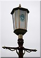
Provost's lamp, John Street
One of two decorative Victorian cast-iron lamps, outside number 68 [https://www.geograph.org.uk/photo/6077123]. The lanterns have stained glass panes depicting the coats of arms of Helensburgh, Dumbartonshire and Strathclyde Region. They are Category B listed.
Image: © Richard Sutcliffe
Taken: 1 Mar 2019
0.16 miles