IMAGES TAKEN NEAR TO
Colquhoun Street, HELENSBURGH, G84 9JW
Introduction
This page details the photographs taken nearby to Colquhoun Street, G84 9JW by members of the Geograph project.
The Geograph project started in 2005 with the aim of publishing, organising and preserving representative images for every square kilometre of Great Britain, Ireland and the Isle of Man.

There are currently over 7.5m images from over14,400 individuals and you can help contribute to the project by visiting https://www.geograph.org.uk
Image Map
Images are licensed for reuse under creativecommons.org/licenses/by-sa/2.0
Notes
- Clicking on the map will re-center to the selected point.
- The higher the marker number, the further away the image location is from the centre of the postcode.
Image Listing (151 Images Found)
Images are licensed for reuse under creativecommons.org/licenses/by-sa/2.0
Image
Details
Distance
1
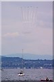
Greenock Esplanade
Tall Ships 2011 Red Arrows approach over Helensburgh.
Image: © Phoebe Marks
Taken: 12 Jul 2011
0.03 miles
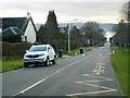
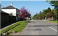
2

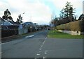
Colquhoun Street, Helensburgh
The picture was taken from the junction with Millig Street. In 1777, James Colquhoun founded this town in what was previously the barony of Malligs (spelled variously at different times), and named it after his wife Helen (hence Helensburgh, Millig Street, Colquhoun Street).
A route called the Three Lochs Way passes through Craigendoran (Image), and follows the main road (Cardross Road / East Clyde Street) from there into Helensburgh. The route then heads uphill, following Colquhoun Street. Not far uphill from the point from which the present photograph was taken, the route makes a small detour around Helensburgh Upper Station: see Image
Image: © Lairich Rig
Taken: 3 May 2012
0.03 miles
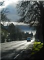
3
James Street
Looking south towards the Clyde.
Image: © Richard Sutcliffe
Taken: 27 Jan 2022
0.05 miles
4
Looking down Sinclair Street
A zoomed view looking towards the Clyde.
Image: © Richard Sutcliffe
Taken: 27 Jan 2022
0.07 miles
5
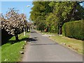
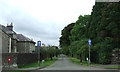
Stafford Street, Helensburgh
The street is shown here from near its junction with Image
Image: © Lairich Rig
Taken: 2 May 2011
0.08 miles
6
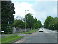
Queen Street
From the junction with Colquhoun Street.
Image: © Richard Sutcliffe
Taken: 27 Jan 2022
0.08 miles
7
Stafford Street
Running west off Sinclair Street.
Image: © Thomas Nugent
Taken: 10 Aug 2013
0.09 miles
9
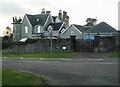
Lomond Junior School and Nursery
A mid-19th century villa on the corner of James Street and Queen Street, remodelled by William Leiper in 1888 and 1891. Formerly known as Clarendon House, now Lomond Junior School and Nursery. It is Category B listed http://portal.historicenvironment.scot/designation/LB34788.
Image: © Richard Sutcliffe
Taken: 27 Jan 2022
0.10 miles
10
Queen Street, Helensburgh
The street is shown here from close to its junction with Image
Image: © Lairich Rig
Taken: 2 May 2011
0.10 miles