IMAGES TAKEN NEAR TO
Blackhill Drive, HELENSBURGH, G84 9HR
Introduction
This page details the photographs taken nearby to Blackhill Drive, G84 9HR by members of the Geograph project.
The Geograph project started in 2005 with the aim of publishing, organising and preserving representative images for every square kilometre of Great Britain, Ireland and the Isle of Man.

There are currently over 7.5m images from over14,400 individuals and you can help contribute to the project by visiting https://www.geograph.org.uk
Image Map
Images are licensed for reuse under creativecommons.org/licenses/by-sa/2.0
Notes
- Clicking on the map will re-center to the selected point.
- The higher the marker number, the further away the image location is from the centre of the postcode.
Image Listing (12 Images Found)
Images are licensed for reuse under creativecommons.org/licenses/by-sa/2.0
Image
Details
Distance
1

Blackhill Drive, Helensburgh
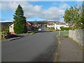
The view is from further along the street that is shown in Image; see that item for further comments. In the present picture, the turning on the right is for Kennedy Drive.
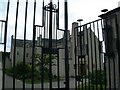
Blackhill Drive itself comes to an end here; although there are no houses directly ahead, the way is blocked, so that there is no access to the moor.
Image: © Lairich Rig
Taken: 1 Nov 2016
0.04 miles
2
Blackhill Drive, Helensburgh
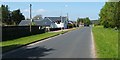
Blackhill Drive is one of the outlying parts of Helensburgh; as the map shows, the Glennan Burn flows just to its west.
The name Blackhill has, in modern times, been associated with the upper parts of Helensburgh, and the area just above it: see, for example, Image and Image
The item Image has further comments about the Black Hill.
In the present picture, the turning for Glen Drive is not far ahead, on the right. For a view from further ahead, near the end of this road, see Image
Image: © Lairich Rig
Taken: 1 Nov 2016
0.10 miles
3
Kennedy Drive, Helensburgh
This picture was taken from near the junction with Image
Image: © Lairich Rig
Taken: 2 May 2011
0.19 miles
4
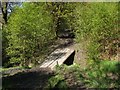
Footbridge on the Upland Way
This is one of several footbridges on this path that cross small burns. They all have the same design: see Image and Image for other examples.
Image: © Lairich Rig
Taken: 12 May 2009
0.20 miles
6

West Lennox Drive, Helensburgh
Not far ahead, the road turns right, with a change of name to Blackhill Drive: Image
Image: © Lairich Rig
Taken: 1 Nov 2016
0.20 miles
7

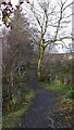
Highlandman's Path
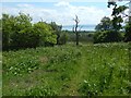
This part of the footpath skirts the edge of the wood and the open moorland.
Image: © Mary and Angus Hogg
Taken: 1 Mar 2013
0.21 miles

10
Wooded slope above Helensburgh
OS maps at some scales reckon this a part of Blackhill Plantation. The Firth of Clyde can be seen through the gap. The view is from Image
Image: © Lairich Rig
Taken: 30 May 2018
0.24 miles