IMAGES TAKEN NEAR TO
West Douglas Drive, HELENSBURGH, G84 9AL
Introduction
This page details the photographs taken nearby to West Douglas Drive, G84 9AL by members of the Geograph project.
The Geograph project started in 2005 with the aim of publishing, organising and preserving representative images for every square kilometre of Great Britain, Ireland and the Isle of Man.

There are currently over 7.5m images from over14,400 individuals and you can help contribute to the project by visiting https://www.geograph.org.uk
Image Map
Images are licensed for reuse under creativecommons.org/licenses/by-sa/2.0
Notes
- Clicking on the map will re-center to the selected point.
- The higher the marker number, the further away the image location is from the centre of the postcode.
Image Listing (140 Images Found)
Images are licensed for reuse under creativecommons.org/licenses/by-sa/2.0
Image
Details
Distance
1
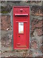
Edwardian Postbox
Located at the corner of West Dhuhill Drive and Sinclair Street.
Image: © Lairich Rig
Taken: 26 Sep 2008
0.00 miles
2
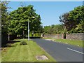
West Dhuhill Drive, Helensburgh
This photograph was taken from the junction with Image; the latter divides many of the streets of Helensburgh into East and West sections. By a quirk of naming, the opposite number of this street, behind the photographer's position, is called Dhuhill Drive East, not East Dhuhill Drive.
Image: © Lairich Rig
Taken: 2 May 2011
0.02 miles
3
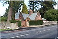
Dhuhill Lodge
This building caught my attention because it has the look of a lodge. It is located at the junction of Image and Image, and it was built as a lodge for Dhuhill House (Image).
Its listed building report provides further details: http://portal.historic-scotland.gov.uk/designation/LB34864 (at Historic Environment Scotland).
Image: © Lairich Rig
Taken: 26 Oct 2011
0.04 miles
4
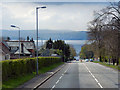
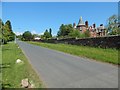
Sinclair Street, Helensburgh
Approaching Helensburgh on the A818. Ahead is the Clyde Estuary and, beyond, Greenock.
Image: © David Dixon
Taken: 19 Apr 2012
0.05 miles
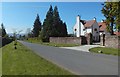
5
Upper Colquhoun Street, Helensburgh
The view is from the junction with Douglas Drive.
The building to the right is Red Towers (1898; architect William Leiper; category A listed).
Image: © Lairich Rig
Taken: 30 May 2018
0.06 miles
6
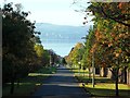
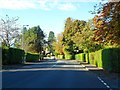
Upper Colquhoun Street, Helensburgh
Stunning view of the autumn colours, and to the River Clyde.
Image: © Stephen Sweeney
Taken: 9 Oct 2012
0.07 miles
7
Upper Colquhoun Street, Helensburgh
The building to the right is the White House. Though overshadowed by the Hill House (Image), which is behind the photographer's position, the White House has much to commend it.
It was built for Henry S Paul, a director of Matthew Paul & Co.; he seems to have been better known locally as Harry S Paul. I believe he was the son of the Andrew Paul who is mentioned at Image, and therefore the grandson of the Matthew Paul who is described at Image
The house dates from the 1890s; the architect was Mackay Hugh Baillie Scott. A detailed description can be found in the building's listing text.
Image: © Lairich Rig
Taken: 3 May 2017
0.07 miles
9
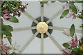
Sculptural installation at Hill House
This funny little greenhouse designed so only one person can get in at a time to be faced with heavenly lilies. The view is actually up.
Image: © Andrya Prescott
Taken: 16 Jul 2005
0.09 miles
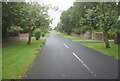
10
Sinclair Street, Helensburgh
From the corner of Kennedy Drive.
Image: © Stephen Sweeney
Taken: 9 Oct 2012
0.10 miles