IMAGES TAKEN NEAR TO
West Lennox Drive, HELENSBURGH, G84 9AD
Introduction
This page details the photographs taken nearby to West Lennox Drive, G84 9AD by members of the Geograph project.
The Geograph project started in 2005 with the aim of publishing, organising and preserving representative images for every square kilometre of Great Britain, Ireland and the Isle of Man.

There are currently over 7.5m images from over14,400 individuals and you can help contribute to the project by visiting https://www.geograph.org.uk
Image Map
Images are licensed for reuse under creativecommons.org/licenses/by-sa/2.0
Notes
- Clicking on the map will re-center to the selected point.
- The higher the marker number, the further away the image location is from the centre of the postcode.
Image Listing (128 Images Found)
Images are licensed for reuse under creativecommons.org/licenses/by-sa/2.0
Image
Details
Distance
1
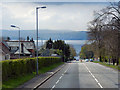
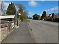
Sinclair Street, Helensburgh
Approaching Helensburgh on the A818. Ahead is the Clyde Estuary and, beyond, Greenock.
Image: © David Dixon
Taken: 19 Apr 2012
0.04 miles
3
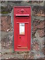
Edwardian Postbox
Located at the corner of West Dhuhill Drive and Sinclair Street.
Image: © Lairich Rig
Taken: 26 Sep 2008
0.08 miles
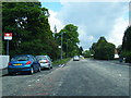
4
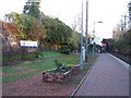
Munro Drive West
Off Sinclair Street at Helensburgh Upper railway station.
Image: © Thomas Nugent
Taken: 10 Aug 2013
0.08 miles
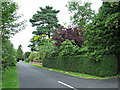
5
Passing Helensburgh Upper Station
A couple of routes, the Three Lochs Way and the John Muir Way, follow the line of Colquhoun Street and Upper Colquhoun Street, but Helensburgh Upper Station intervenes; going around the station means following Sinclair Street (shown here) for a few metres (roughly, from the spot from which the picture was taken, to the next junction on the left, just beyond the railway station sign).
Image: © Lairich Rig
Taken: 14 Apr 2014
0.09 miles
6
Helensburgh, Upper Helensburgh Station
On the West Highland line to Mallaig and Oban
Image: © william craig
Taken: 16 Dec 2005
0.09 miles
7
Helensburgh Upper railway station
A simplified schematic map of the West Highland Lines.
Image: © Thomas Nugent
Taken: 10 Aug 2013
0.09 miles
8
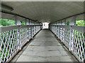
Helensburgh Upper railway station
Looking down the ramp from Sinclair Street bridge.
Image: © Thomas Nugent
Taken: 10 Aug 2013
0.09 miles
9
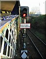
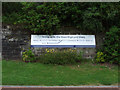
End of radio token working
The West Highland line operates by a radio electronic token block system (see Wikipedia https://en.wikipedia.org/wiki/Radio_Electronic_Token_Block ). Helensburgh Upper is the last station before this line meets the line from Helensburgh Central at Craigendoran which is operated by standard signals - hence the notice 'End of radio Token working'.
Image: © Richard Sutcliffe
Taken: 27 Jan 2022
0.09 miles
10
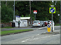
Helensburgh Upper railway station
The entrance on Sinclair Street.
Image: © Thomas Nugent
Taken: 10 Aug 2013
0.09 miles