IMAGES TAKEN NEAR TO
Main Road, HELENSBURGH, G84 8RL
Introduction
This page details the photographs taken nearby to Main Road, G84 8RL by members of the Geograph project.
The Geograph project started in 2005 with the aim of publishing, organising and preserving representative images for every square kilometre of Great Britain, Ireland and the Isle of Man.

There are currently over 7.5m images from over14,400 individuals and you can help contribute to the project by visiting https://www.geograph.org.uk
Image Map
Images are licensed for reuse under creativecommons.org/licenses/by-sa/2.0
Notes
- Clicking on the map will re-center to the selected point.
- The higher the marker number, the further away the image location is from the centre of the postcode.
Image Listing (76 Images Found)
Images are licensed for reuse under creativecommons.org/licenses/by-sa/2.0
Image
Details
Distance
1
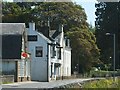
Rhu post office and inn
This picture was taken with the Domesday Reloaded project in mind, and was an attempt to recreate an older photograph, which could (at the time) be seen at the BBC's Domesday Reloaded site.
For the front of the inn, see also Image
The wall that appears in the foreground, on the right, is at the top of the beach. The photograph was taken from a point near the Image
Image: © Lairich Rig
Taken: 3 Jun 2011
0.01 miles
2
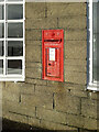
Rhu Postbox
King Edward VII Postbox (he reigned 1901-1910). It is mounted in the wall of the Rhu Post Office which closed in 2018. The wall appears to be considerably newer than the postbox. The Post Office is just west of the Rhu Inn (which reopened in October 2022). Both buildings are in the village of Rhu on the north side of the A814 Gareloch Road.
Image: © Pete Marrison
Taken: 23 Nov 2022
0.01 miles
5
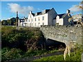
Burn flowing under the road at Rhu
As shown on the map, a burn flows under the road here; it passes under this bridge.
Image are in the background.
Image: © Lairich Rig
Taken: 1 Nov 2016
0.04 miles
6
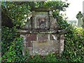
Memorial for Robert Anderson
The stone is set into the southern boundary wall of the kirkyard of Image The stone long pre-dates the present church.
On its reverse (close to the war memorial shown in Image) is the following inscription:
"Out Of Loue And Respeicte The Paerish Had To There Minister They Bulded This Tomb 1709".
John Smith (see the works cited at the end), writing in 1849, described the stone as being "Chinese-shaped rather"; it is, but I doubt whether this conveyed much information to the average reader of those times.
The near side bears fairly typical emblems of mortality: an hourglass, skull, and crossbones. Below them is the worn carved representation of a head. Below the head is the following inscription:
"Hic situs est Mr Robertus Anderson qui cum ecclesiæ Rowensi per quinque plus minus lustra summa cum laude nec minore fructu præfuisset immatura quamvis morte in ipso ætatis vigore præreptus famam tamen sibi superstitem monumento hoc lapidio longe perenniorem reliquit.
Decessit Cal. Mart. Anno Dom. MDCCVIII."
As noted there, he was minister of the congregation of Row (now spelled Rhu) for about 25 years ("per quinque plus minus lustra", literally "for five lustra, more or less"). He succeeded Hugh Gordon of Comrie in 1684; during Gordon's ministry, the congregation were following an Episcopalian form of worship, and Anderson did likewise in his first few years at Rhu. His ministry there was not without interruption: at around the time of the 1688 Revolution (the overthrow of James VII), Anderson took up the Second Charge at Dumbarton. Later, with the restoration of Presbyterianism, he again accepted the call to become minister at Rhu, though he now did so on Presbyterian lines. He died on the first of March 1708, aged around 53.
References:
• The Latin inscription, though still mostly legible today, is transcribed in:
John Smith, "Our Scottish Clergy" (1849), Second Series, page 136.
• A detailed listing of the succession of ministers at Row/Rhu appears in:
"Fasti Ecclesiæ Scoticanæ" (1920), volume 3, page 365.
• A summary listing of the same succession is given in:
Joseph Irving, "The Book of Dumbartonshire" (1879), volume 2, page 303.
Image: © Lairich Rig
Taken: 19 May 2014
0.04 miles
7
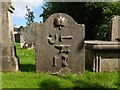
Memorial to William Muir
This stone is in the older part of the kirkyard of Image The other side of the stone is rather worn, but its inscription commemorates William Muir, a smith, and his wife, Margaret Turner. The text on this side reads "W.M. / Erected in 1801".
As well as emblems of mortality, the carvings include a crown (top), and some recognisable symbols of the smith's craft. The symbol at the bottom probably represents bellows.
For context, see Image, where the position of this stone is picked out.
Image: © Lairich Rig
Taken: 12 Sep 2012
0.04 miles
8
NEW
Memorial for Robert Anderson
The memorial dating from 1709 is for a former minister of the church. See Lairich Rig's Image for a full description.
Image: © Richard Sutcliffe
Taken: 22 Feb 2025
0.04 miles
9
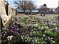
NEW
Crocuses galore
According to a church member, the crocuses were first planted in the graveyard of Rhu Parish Church (as it was then) over 100 years ago. They have certainly flourished and provide a great spectacle at this time of year. Rhu and Shandon Parish Church were holding a "Crocus Tea" in their church hall on this particular afternoon.
Image: © Richard Sutcliffe
Taken: 22 Feb 2025
0.04 miles
10

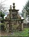
Memorial to Captain Robert Bain
The flat stone (actually iron) is located in the kirkyard of Image, and lies to the south-east of the church. The elegantly-carved inscription is worth reproducing in full:
"To the Memory of Captain Robert Bain, born May 1788, departed this Life at Fort William, Dec. 1827, aged 39 years.
- - • - -
C R Bain was appointed by H Bell, to the command of the Comet Steam Boat in 1814, by which Vessel a communication was opened up between the Western Islands of Scotland and Glasgow, through the Crinan Canal in July 1819. He was the first Captain who commanded a Vessel from Sea to Sea, through the great Caledonian Canal, in 1822.
- - • - -
This was erected as a tribute of honour, for 16 years faithful service,
By Henry Bell, Engineer, Helensburgh.
- - • - -
Cast and completely finished At The Shotts Iron Company's Works
John Baird Manager
1829."
Henry Bell, mentioned here, is buried not far away in the same kirkyard: Image
A Image is displayed on the shore at Helensburgh, about 2 miles away, Image, along with an Image See also Image
Image: © Lairich Rig
Taken: 12 Sep 2012
0.04 miles