IMAGES TAKEN NEAR TO
Loch Drive, HELENSBURGH, G84 8PZ
Introduction
This page details the photographs taken nearby to Loch Drive, G84 8PZ by members of the Geograph project.
The Geograph project started in 2005 with the aim of publishing, organising and preserving representative images for every square kilometre of Great Britain, Ireland and the Isle of Man.

There are currently over 7.5m images from over14,400 individuals and you can help contribute to the project by visiting https://www.geograph.org.uk
Image Map
Images are licensed for reuse under creativecommons.org/licenses/by-sa/2.0
Notes
- Clicking on the map will re-center to the selected point.
- The higher the marker number, the further away the image location is from the centre of the postcode.
Image Listing (80 Images Found)
Images are licensed for reuse under creativecommons.org/licenses/by-sa/2.0
Image
Details
Distance
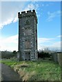
2
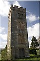
Ardencaple Tower, Helensburgh
All that is left of Ardencaple Castle, which was demolished in 1957-58. The original castle is said to date from the 13th century, but most was built in 1583 by the 11th laird. The Castle was the traditional home of the Clan MacAulay from the 13th to 18th century. See also Image
Image: © Becky Williamson
Taken: 7 Apr 2011
0.06 miles
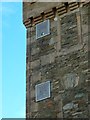
3
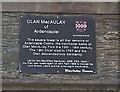
Plaque on Ardencaple Tower, Helensburgh
The original castle is said to date from the 13th century, but most was built in 1583 by the 11th laird. The NW tower is all that is left of the Castle today. See also Image]
Image: © Becky Williamson
Taken: 7 Apr 2011
0.06 miles
4
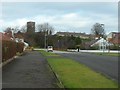
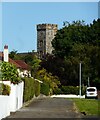
Castle Avenue, Helensburgh
Looking towards Ardencaple Tower - the last remains of the castle after which the street is named.
Image: © Stephen Sweeney
Taken: 19 Feb 2012
0.07 miles
5
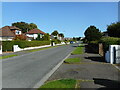
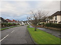
Cumberland Street
Residential street in Helensburgh.
Image: © Richard Sutcliffe
Taken: 5 Sep 2023
0.07 miles
6
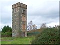
Ardencaple Tower
For further details, click on the end-note title. For other contributors' pictures, see Image and Image
For context, and for a discussion of how the geology of the area influenced the choice of this site as the location of a castle, see Image See also Image for further context.
Apart from this one tower, what remained of Ardencaple Castle was demolished c.1957 to make way for housing (this being Helensburgh, the housing was intended mainly for naval personnel). The tower is located near the junction of Frazer Avenue and West King Street.
Image: © Lairich Rig
Taken: 26 Oct 2011
0.07 miles
7
Ardencaple Castle
The tower is all that now remains of the Category B listed https://portal.historicenvironment.scot/designation/LB34703 Ardencaple Castle. Originally the seat of the Clan MacAulay the castle fell into ruin and was sold off in the 1760s. It was repaired and altered in the 1780s and further alterations were made in 1877. The rest of the castle was demolished in 1957.
Image: © Richard Sutcliffe
Taken: 5 Sep 2023
0.07 miles
8
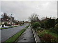
Cumberland Avenue
Suburban Helensburgh.
Image: © Jonathan Thacker
Taken: 23 Nov 2018
0.07 miles
9
Ardencaple Tower: navigation lights
There are two fixed green lights near the top of one side of Ardencaple Tower, which is also, for the purposes of navigation, known as Ardencaple Castle Light. The tower itself is the sole standing remnant of Ardencaple Castle.
For context, see Image, a view of the whole tower; the lights can be seen in that picture. For related pictures, click on the end-note title.
Image: © Lairich Rig
Taken: 17 Nov 2014
0.08 miles
10
Ardencaple Tower
This is the sole standing remnant of Ardencaple Castle. For other pictures of the tower, click on the end-note title. See also Image and Image for other contributors' pictures.
Image: © Lairich Rig
Taken: 17 Nov 2014
0.08 miles