IMAGES TAKEN NEAR TO
Maidstone Road, HELENSBURGH, G84 8PB
Introduction
This page details the photographs taken nearby to Maidstone Road, G84 8PB by members of the Geograph project.
The Geograph project started in 2005 with the aim of publishing, organising and preserving representative images for every square kilometre of Great Britain, Ireland and the Isle of Man.

There are currently over 7.5m images from over14,400 individuals and you can help contribute to the project by visiting https://www.geograph.org.uk
Image Map
Images are licensed for reuse under creativecommons.org/licenses/by-sa/2.0
Notes
- Clicking on the map will re-center to the selected point.
- The higher the marker number, the further away the image location is from the centre of the postcode.
Image Listing (21 Images Found)
Images are licensed for reuse under creativecommons.org/licenses/by-sa/2.0
Image
Details
Distance
1
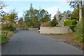
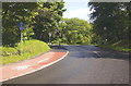
Old Shore Road and former South Lodge
The building on the right looks like a lodge; old maps confirm that it was a lodge of West Shandon House.
The latter is now gone, but it was built as a mansion house for Robert Napier (for more on him and the mansion house, and for links to further information, see Image). West Shandon House was later used as a hydropathic establishment, and is labelled as such on some maps.
For a different part of the same road, see another contributor's earlier picture: Image
Image: © Lairich Rig
Taken: 15 Oct 2012
0.02 miles
2
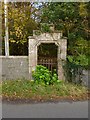
Old entrance to grounds of Shandon House
This entrance now seems strangely positioned, at one side of a narrow strip of woodland between two roads. However, before the main road (A814) was built, this can only have been an entrance to the south-western part of the grounds of Shandon House. At the time of submission, Shandon House itself is still standing: Image / Image
The present picture was taken from the old shore road (see Image, taken from about the same spot).
Image: © Lairich Rig
Taken: 15 Oct 2012
0.02 miles
3
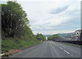
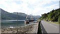
A814 downhill into Shandon
Passed Faslane base
Image: © John Firth
Taken: 11 May 2012
0.04 miles

5
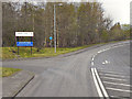
A814 Faslane
The A814 at the south entrance the naval base.
Image: © David Dixon
Taken: 19 Apr 2012
0.09 miles
6

Station Road, Shandon
This is a view of the road on its approach to the main road (A814). For a view in the opposite direction from the same point, see Image
In connection with the former Shandon Station and the railway lines here, see Image / Image / Image
Image: © Lairich Rig
Taken: 15 Oct 2012
0.09 miles
7
Cycle Path Shandon
Cycle Path Shandon, looking towards the junction on the A814 near south entrance to Faslane.
Image: © George Rankin
Taken: 25 May 2007
0.09 miles
9

Station Road, Shandon
Further along this road, there used to be a Shandon Station on the West Highland Railway Line; hence the name of the road. For a while, from 1941 onwards, there was, in addition, a level crossing for a separate line, the Faslane Branch.
See Image for a view in the opposite direction from the same point.
On Shandon Station and the separate Faslane Branch, see also Image and Image
Image: © Lairich Rig
Taken: 15 Oct 2012
0.14 miles
10
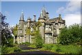
Former Shandon House (St. Andrew's School), Shandon, Dunbartonshire
Rambling Scots baronial mansion with Jacobethan detailing by Charles Wilson, built for William Jamieson in 1849 to replace an earlier house and set in about 31 acres of grounds overlooking Gare Loch. Now owned by the MOD, the property has lain empty and deteriorating for over a decade, its good quality fittings and plaster work decaying, its setting compromised by the depressing remains of derelict structures associated with its last use as a "list D" remand home. The MOD's plans to use the building and its grounds did not materialise and they are now keen to dispose of it (offers invited)
Image: © George Rankin
Taken: 25 May 2007
0.14 miles