IMAGES TAKEN NEAR TO
Lineside Walk, HELENSBURGH, G84 8JJ
Introduction
This page details the photographs taken nearby to Lineside Walk, G84 8JJ by members of the Geograph project.
The Geograph project started in 2005 with the aim of publishing, organising and preserving representative images for every square kilometre of Great Britain, Ireland and the Isle of Man.

There are currently over 7.5m images from over14,400 individuals and you can help contribute to the project by visiting https://www.geograph.org.uk
Image Map
Images are licensed for reuse under creativecommons.org/licenses/by-sa/2.0
Notes
- Clicking on the map will re-center to the selected point.
- The higher the marker number, the further away the image location is from the centre of the postcode.
Image Listing (14 Images Found)
Images are licensed for reuse under creativecommons.org/licenses/by-sa/2.0
Image
Details
Distance
1
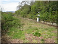
Rhu railway station (site), Argyll and Bute
Opened in 1894 as 'Row' by the West Highland Railway, later part of the North British Railway, on the line from Helensburgh to Fort William. The name was changed to Rhu in 1924 and closed to passengers in 1954. It was reopened from 1960 to 1964.
View north west from Station Road. The platforms appeared to still be extant when this image was taken.
Image: © Nigel Thompson
Taken: 4 May 2017
0.07 miles
2
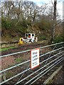
Former Rhu Railway Station
Operational from 1894-1956, and again briefly form 1960-1964.
Image: © Stephen Sweeney
Taken: 19 Feb 2012
0.07 miles
3
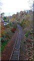
Single track line to Oban and Fort William
Image: © Gordon Brown
Taken: 16 Nov 2019
0.14 miles
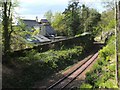
4
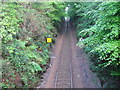
The West Highland Line at Torr
A view looking southeast from the bridge at Torr, along the West Highland railway line as it descends through a deep cutting towards Helensburgh.
Image: © Phil Williams
Taken: 28 May 2006
0.14 miles
5
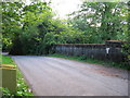
Torr Bridge
A view looking to the southwest towards the bridge at Torr over the West highland railway line.
Image: © Phil Williams
Taken: 28 May 2006
0.14 miles
6
West Highland Line at Rhu
This view was taken from a bridge ( http://www.geograph.org.uk/photo/178851 ); for a view from the same bridge, but looking in the opposite direction, see http://www.geograph.org.uk/photo/178847
Image: © Lairich Rig
Taken: 14 May 2009
0.15 miles
7
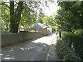
Looking down Station Road
The photograph was taken from near the entrance to Torr Crescent.
Image: © Lairich Rig
Taken: 5 Oct 2008
0.15 miles
8
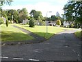
Torr Crescent
This little estate is located beside Station Road in Rhu.
Image: © Lairich Rig
Taken: 5 Oct 2008
0.18 miles
9
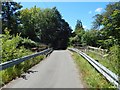
Bridge over West Highland Line at Torr
The railings and barriers are recent; compare another contributor's earlier picture: Image
Image: © Lairich Rig
Taken: 9 Jul 2014
0.18 miles
10
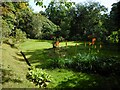
Open space
An open space within the woodland garden. Kniphofias (red hot pokers) are in flower.
Image: © Richard Sutcliffe
Taken: 5 Sep 2023
0.21 miles