IMAGES TAKEN NEAR TO
Campbell Street, HELENSBURGH, G84 8BQ
Introduction
This page details the photographs taken nearby to Campbell Street, G84 8BQ by members of the Geograph project.
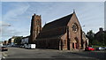
The Geograph project started in 2005 with the aim of publishing, organising and preserving representative images for every square kilometre of Great Britain, Ireland and the Isle of Man.

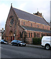
There are currently over 7.5m images from over14,400 individuals and you can help contribute to the project by visiting https://www.geograph.org.uk
Image Map
Images are licensed for reuse under creativecommons.org/licenses/by-sa/2.0
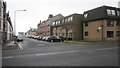
Notes
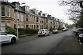
- Clicking on the map will re-center to the selected point.
- The higher the marker number, the further away the image location is from the centre of the postcode.
Image Listing (204 Images Found)
Images are licensed for reuse under creativecommons.org/licenses/by-sa/2.0
Image
Details
Distance

2
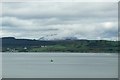
Helensburgh and Ben Lomond viewed from P&O's Adonia, sailing into Greenock
See also ...
Image
Image: © Terry Robinson
Taken: 7 Oct 2012
0.06 miles
3
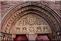
Carved panels, St Michael and All Angels' Church, Helensburgh
Above the doors of the Category A listed church, facing William Street.
Image: © Richard Sutcliffe
Taken: 29 Dec 2018
0.07 miles
4
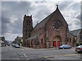
The Church of St Michael and All Angels
The present church, dedicated to St Michael and All Angels, was consecrated in 1868. It is on the site of an earlier, smaller, church (dedicated to the Holy Trinity) dating from 1843 (http://www.helensburgh-heritage.co.uk/index.php?option=com_content&view=article&id=474:st-michaels-church-a-short-history&catid=91:religion-&Itemid=492 - Helensburgh Heritage)
Image: © David Dixon
Taken: 19 Apr 2012
0.08 miles
5
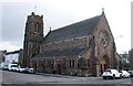
St Michael and All Angels' Church, Helensburgh
Category A listed [http://portal.historicenvironment.scot/designation/LB34896] Episcopal church, mainly dating from 1866-1868, with the tower added in 1930.
Image: © Richard Sutcliffe
Taken: 29 Dec 2018
0.08 miles
6
St Michael and All Angels' Church, Helensburgh
Category A listed [http://portal.historicenvironment.scot/designation/LB34896] Episcopal church, mainly dating from 1866-1868, with the tower added in 1930.
Image: © Richard Sutcliffe
Taken: 29 Dec 2018
0.08 miles
7
Helensburgh - St Michaels & All Angels Church
Image: © Colin Park
Taken: 3 Jul 2017
0.08 miles
8
John Street
Looking from the junction with West King Street.
Image: © Richard Sutcliffe
Taken: 1 Mar 2019
0.10 miles
9
Glenan Gardens, Argyle Street West
The whole late 19th century terrace (numbers 1-14) are Category C listed buildings [http://portal.historicenvironment.scot/designation/LB34783].
Image: © Richard Sutcliffe
Taken: 1 Mar 2019
0.10 miles
10
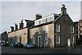
Properties on West Princes Street, Helensburgh
Image: © Richard Sutcliffe
Taken: 24 Dec 2019
0.10 miles