IMAGES TAKEN NEAR TO
Redgauntlet Road, HELENSBURGH, G84 7TZ
Introduction
This page details the photographs taken nearby to Redgauntlet Road, G84 7TZ by members of the Geograph project.
The Geograph project started in 2005 with the aim of publishing, organising and preserving representative images for every square kilometre of Great Britain, Ireland and the Isle of Man.

There are currently over 7.5m images from over14,400 individuals and you can help contribute to the project by visiting https://www.geograph.org.uk
Image Map
Images are licensed for reuse under creativecommons.org/licenses/by-sa/2.0
Notes
- Clicking on the map will re-center to the selected point.
- The higher the marker number, the further away the image location is from the centre of the postcode.
Image Listing (66 Images Found)
Images are licensed for reuse under creativecommons.org/licenses/by-sa/2.0
Image
Details
Distance
1
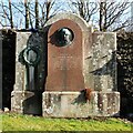
Memorial to a minister
Against the wall of the cemetery close to the entrance.
IN MEMORY OF
THE REVD JOHN ANDERSON.
FORTY YEARS
MINISTER IN HELENSBURGH,
DIED 10TH JANY 1867,
IN THE SIXTY-SECOND YEAR
OF HIS AGE.
“UNTIL THE DAY BREAK, AND THE SHADOWS FLEE AWAY.”
Image: © Richard Sutcliffe
Taken: 4 Mar 2024
0.04 miles
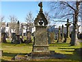
2
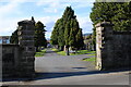
Entrance to Helensburgh Cemetery
On Old Luss Road. The cemetery, which is Category B listed https://portal.historicenvironment.scot/designation/LB34824 contains 41 Commonwealth War Graves and many other notable memorials.
The lodge house that used to be beside the gates was demolished after this photograph Image was taken in 2013.
Image: © Richard Sutcliffe
Taken: 4 Mar 2024
0.05 miles
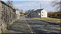
3
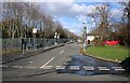
Redgauntlet Road
This section of Redgauntlet Road leads to Colgrain Primary School at the far end.
Image: © Richard Sutcliffe
Taken: 4 Mar 2024
0.05 miles
5
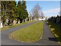
Helensburgh Cemetery
This is the eastern boundary of the cemetery. At the far end of the path on the right, a memorial for the Kidstons of Ferniegair is visible (I have not depicted it separately, since several of the names on it are recent). Helensburgh's Image is named after a member of that family; see that link for further details.
See also Image Click on the end-note title for other views of the cemetery.
Image: © Lairich Rig
Taken: 27 Mar 2013
0.05 miles
6
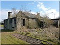
Helensburgh Cemetery: old gate-lodge
For context, see Image The present view is from the other side.
This former gate-lodge was in poor condition; it was set to be demolished, its situation making a conversion to residential use impractical. By 2014, the building had been cleared away.
Image: © Lairich Rig
Taken: 27 Mar 2013
0.05 miles
7
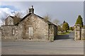
Helensburgh Cemetery: entrance
This entrance is on Old Luss Road. The building just to the left of the entrance is the old gate lodge, which was in poor condition: Image By 2014, it had been demolished.
Image: © Lairich Rig
Taken: 27 Mar 2013
0.05 miles
8
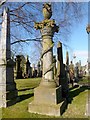
Memorial to Janet Walker
This finely carved memorial was "erected by Thomas Weir, writer, Glasgow, and Jeanie MacIndoe, his wife, in memory of their daughter, Janet Walker, (Nettie), born 3rd September 1876, died 1[4th July 1881?]" (part of the inscription has flaked off). The parents, and other members of the family, are also commemorated. "Writer", as Thomas Weir is described in the inscription, was then the usual term for a lawyer, notary, or solicitor.
This is one of the memorials that is specifically mentioned in the cemetery's listing text (see the end-note for a link). The memorial, which is located near the eastern edge of the cemetery (Image), is described there as a composite column entwined with bay leaf garland.
The sculptor was T F Hunter of Glasgow. He was one of the founders of Hunter & Clark, a firm that was in existence until recently, and he had previously been one of the partners of the firm Arnott & Hunter.
Image: © Lairich Rig
Taken: 27 Mar 2013
0.05 miles
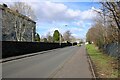
9
Old Luss Road
On the left is the eastern boundary wall of Image Not far ahead, the name Kirkmichael appears on the signs. This is an old name, long pre-dating the name Helensburgh: for example, the lands of Kirkmichael Stirling were, in the middle of the fifteenth century, the subject of a dispute between William Stirling, Laird of Cadder, and Gilbert Stirling.
Rather earlier, the Lennox Cartulary contains a charter confirming to Walter of Fosselane (Faslane) various lands, including those of "Keppach (Keppoch Image), de Culgrayane (Colgrain Image), de Camceskanys (Camis Eskan Image), de Kirkmychell, etc.", that had earlier been granted by Malcolm Earl of Lennox (d.1333) to Avileth* of Fosselane. (The grid references given here simply indicate where the modern equivalents of those names appear on present-day maps; they are not intended to give the exact location of the original lands.)
(*) Or "Aulay". This Avileth or Aulay of Faslane was the grandson of an Earl of Lennox. The name was held by several members of the family, and charters variously spell it Auleth, Ameleth, Amelech, Amhlew, Hamelen, and so on, but all of those forms can be thought of as essentially being the name "Aulay" (as in Clan MacAulay).
Image: © Lairich Rig
Taken: 27 Mar 2013
0.05 miles
10
The Oughterson Memorial
The stone commemorates several descendants of Arthur Oughterson and of his wife Janet Robertson. Some of them were interred here, and others in South America.
(The structure has some near twins in the same cemetery: a memorial to the builder James McKinnon, signed "J Craig", and a memorial to "Robert Hendry, Esq, chemist and druggist", signed "D Garland".)
Image: © Lairich Rig
Taken: 27 Mar 2013
0.06 miles