IMAGES TAKEN NEAR TO
Prince Albert Terrace, HELENSBURGH, G84 7RY
Introduction
This page details the photographs taken nearby to Prince Albert Terrace, G84 7RY by members of the Geograph project.
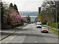
The Geograph project started in 2005 with the aim of publishing, organising and preserving representative images for every square kilometre of Great Britain, Ireland and the Isle of Man.

There are currently over 7.5m images from over14,400 individuals and you can help contribute to the project by visiting https://www.geograph.org.uk
Image Map
Images are licensed for reuse under creativecommons.org/licenses/by-sa/2.0
Notes
- Clicking on the map will re-center to the selected point.
- The higher the marker number, the further away the image location is from the centre of the postcode.
Image Listing (115 Images Found)
Images are licensed for reuse under creativecommons.org/licenses/by-sa/2.0
Image
Details
Distance
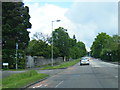
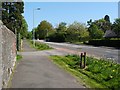
1
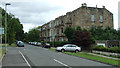
Victoria Road
Running east off Sinclair Street.
Image: © Thomas Nugent
Taken: 10 Aug 2013
0.01 miles
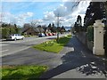
2
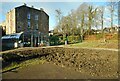
Demonstration garden
Part of a demonstration garden being developed in Hermitage Park, Helensburgh.
Image: © Richard Sutcliffe
Taken: 27 Jan 2022
0.03 miles
3
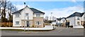
Victoria Grove
At the time of writing, this housing development on the northern side of Victoria Road was fairly new.
Image: © Lairich Rig
Taken: 27 Mar 2013
0.03 miles
4
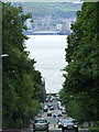
Sinclair Street
Looking down the steep hill from Helensburgh Upper railway station, Greenock can be seen across the Firth of Clyde. A march or parade is taking place in the town centre at the bottom of the hill.
Image: © Thomas Nugent
Taken: 10 Aug 2013
0.04 miles
5
Helensburgh
Looking down Sinclair Street, towards the town centre and the Clyde Estuary; with Greenock on the far side of the river.
Image: © David Dixon
Taken: 19 Apr 2012
0.05 miles
6
Sinclair Street, Helensburgh
The subject matter (road and roadside flowers) is as in Image, but the view is from further downhill, below the junction with Millig Street.
Image: © Lairich Rig
Taken: 9 Apr 2016
0.05 miles
7
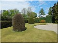
Hermitage Park: the walled garden
The picture was taken in the western half of the walled garden.
Image: © Lairich Rig
Taken: 28 Apr 2014
0.06 miles
9
Sinclair Street, Helensburgh
The road is shown here from just below its junction, on the left, with Image
Image: © Lairich Rig
Taken: 2 May 2011
0.06 miles
10
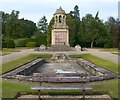
War Memorial in Hermitage Park
The photograph was taken from the (locked) Image The memorial is centred on Image See Image for a wider view.
For a closer look at the inscription, see Image For the upper part of the structure, see Image
Image: © Lairich Rig
Taken: 17 Sep 2010
0.06 miles