IMAGES TAKEN NEAR TO
East Clyde Street, HELENSBURGH, G84 7PF
Introduction
This page details the photographs taken nearby to East Clyde Street, G84 7PF by members of the Geograph project.
The Geograph project started in 2005 with the aim of publishing, organising and preserving representative images for every square kilometre of Great Britain, Ireland and the Isle of Man.

There are currently over 7.5m images from over14,400 individuals and you can help contribute to the project by visiting https://www.geograph.org.uk
Image Map
Images are licensed for reuse under creativecommons.org/licenses/by-sa/2.0
Notes
- Clicking on the map will re-center to the selected point.
- The higher the marker number, the further away the image location is from the centre of the postcode.
Image Listing (266 Images Found)
Images are licensed for reuse under creativecommons.org/licenses/by-sa/2.0
Image
Details
Distance
1
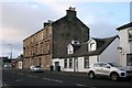
Tenement and cottage, East Clyde Street, Helensburgh
Image: © Richard Sutcliffe
Taken: 24 Dec 2019
0.01 miles
2
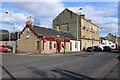
Argyll Bar
At the corner of East Clyde Street and Maitland Court.
Image: © Richard Sutcliffe
Taken: 4 Mar 2024
0.02 miles
3
The Argyll Bar
At the corner of East Clyde Street and Maitland Court.
Image: © Richard Sutcliffe
Taken: 24 Dec 2019
0.02 miles
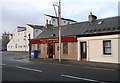
4
Bonar Law House and plaque
This unassuming building was once the Caretaker’s House for the Clyde Street School in Helensburgh.
A plaque now names it as “Bonar Law House” in recognition of Prime Minister Andrew Bonar Law whose married home was “Seabank” at nearby 40 East Clyde Street.
“Seabank” was demolished in the 1950s. An 1860 OS six inch map shows Seabank to be directly opposite the end of Grant Street and set back from Clyde Street at the same distance as 26 East Clyde Street which still exists. Seabank would therefore have been at the south west corner of what is now the Helensburgh and Lomond Civic Centre.
Andrew Bonar Law was born in Canada of Scottish parents and returned to Scotland as a teenager.
As Prime Minister, Bonar Law held office for 209 days between 1922 and 1923. He died in October 1923.
Image: © Pete Marrison
Taken: 7 Jan 2023
0.02 miles
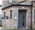
5
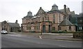
Helensburgh and Lomond Civic Centre
Category B listed [http://portal.historicenvironment.scot/designation/LB45268] former Clyde Street School, now part of the Helensburgh and Lomond Civic Centre.
Image: © Richard Sutcliffe
Taken: 1 Mar 2019
0.02 miles
6
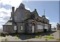
Clyde Street School
This picture of the former school was taken, through railings, from the main road. The girls' entrance was on the left, and the boys' on the right. "Clyde St School" is carved on the front of the building; the larger text above reads "School Board of the Parish of Row" (the place-name Rhu used to be spelled Row, although it was pronounced the same way as at present).
For a view of the building from the opposite side (from the shore), see Image
Image: © Lairich Rig
Taken: 15 May 2013
0.02 miles
7
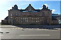
Clyde Street School
This is a view from the other side of East Clyde Street. Click on the end-note title for other views.
Image: © Lairich Rig
Taken: 22 May 2013
0.02 miles
8
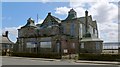
The former Clyde Street School
The building is shown here after refurbishment.
Image: © Lairich Rig
Taken: 22 Sep 2016
0.02 miles
9
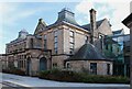
Helensburgh and Lomond Civic Centre
Category B listed https://portal.historicenvironment.scot/designation/LB45268 former Clyde Street School, dating from 1903, now part of the Helensburgh and Lomond Civic Centre.
Image: © Richard Sutcliffe
Taken: 4 Mar 2024
0.02 miles
10
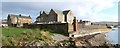
Clyde Street School
This photograph of Clyde Street School (1903) was taken from on top of a ruined wall on the shore (Image). On the left, one of two lodges (west, shown here, and east) that were associated with the disused school can be seen in front of a later building.
Image: © Lairich Rig
Taken: 26 Oct 2011
0.03 miles