IMAGES TAKEN NEAR TO
East Clyde Street, HELENSBURGH, G84 7PA
Introduction
This page details the photographs taken nearby to East Clyde Street, G84 7PA by members of the Geograph project.
The Geograph project started in 2005 with the aim of publishing, organising and preserving representative images for every square kilometre of Great Britain, Ireland and the Isle of Man.

There are currently over 7.5m images from over14,400 individuals and you can help contribute to the project by visiting https://www.geograph.org.uk
Image Map
Images are licensed for reuse under creativecommons.org/licenses/by-sa/2.0
Notes
- Clicking on the map will re-center to the selected point.
- The higher the marker number, the further away the image location is from the centre of the postcode.
Image Listing (429 Images Found)
Images are licensed for reuse under creativecommons.org/licenses/by-sa/2.0
Image
Details
Distance
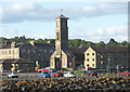
1
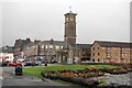
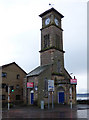
The Clock Tower, Helensburgh
The clock tower also houses the tourist information centre for the town.
Image: © Trevor Harris
Taken: 26 Oct 2010
0.01 miles
2
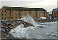
Flats beside the shore
On a very windy day, waves break over the sea wall and into the car park of the flats at Tower Place, built on the site of the former parish church.
Image: © Richard Sutcliffe
Taken: 11 Nov 2022
0.01 miles
3
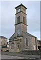
Bell tower, former parish church, Helensburgh
The Category C listed http://portal.historicenvironment.scot/designation/LB34727 tower and west end of the building are all that remain of the former parish church, which was built in 1846. The nave was demolished in 1982.
Image: © Richard Sutcliffe
Taken: 29 Dec 2018
0.01 miles
4
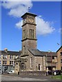
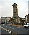
The Clock Tower, Helensburgh
The clock tower at the end of West Clyde Street.
Image: © David P Howard
Taken: 23 Jul 2011
0.02 miles
5
Former Helensburgh Parish Church tower
All that remains of the church on Helensburgh seafront. Category C Listed http://portal.historicenvironment.scot/designation/LB34727 .
Image: © Thomas Nugent
Taken: 18 Nov 2016
0.02 miles
6
Bell tower, former parish church, Helensburgh
The Category C listed https://portal.historicenvironment.scot/apex/f?p=1505:300:::::VIEWTYPE,VIEWREF:designation,LB34727 tower and west end of the building are all that remain of the former parish church, which was built in 1846. The nave was demolished in 1982.
Image: © Richard Sutcliffe
Taken: 11 Nov 2022
0.02 miles
8
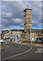
Bell tower, former parish church, Helensburgh
The Category C listed https://portal.historicenvironment.scot/apex/f?p=1505:300:::::VIEWTYPE,VIEWREF:designation,LB34727 tower and west end of the building are all that remain of the former parish church, which was built in 1846. The nave was demolished in 1982.
Image: © Richard Sutcliffe
Taken: 4 Mar 2024
0.02 miles
9

The Clock Tower
Helensburgh Tourist Information Centre is housed within the clock-tower on the waterfront which is a remnant of Charles Wilson's Quoad Sacra Parish Church of 1846 that is Historic Scotland category C listed. Robert Wemyss added the porch in 1923. The nave was demolished in 1982.
Image: © Jo and Steve Turner
Taken: 5 Jun 2012
0.02 miles
10
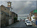
Clock tower and Tourist Information Centre, Helensburgh
For a relatively small town, Helensburgh is endowed with a surprising number of distinguished churches and other interesting and unusual public buildings. It is blessed with an excellent aspect, overlooking the river Clyde, and, to the north of the town centre, many handsome houses and villas built for wealthy shipowners and industrialists of an earlier era. The most famous and visited of these is The Hill House, designed by Charles Rennie Mackintosh in 1902 for Walter Blackie, the Glasgow publisher.
Image: © Anthony O'Neil
Taken: 31 May 2006
0.02 miles