IMAGES TAKEN NEAR TO
Moore Drive, HELENSBURGH, G84 7LE
Introduction
This page details the photographs taken nearby to Moore Drive, G84 7LE by members of the Geograph project.
The Geograph project started in 2005 with the aim of publishing, organising and preserving representative images for every square kilometre of Great Britain, Ireland and the Isle of Man.

There are currently over 7.5m images from over14,400 individuals and you can help contribute to the project by visiting https://www.geograph.org.uk
Image Map
Images are licensed for reuse under creativecommons.org/licenses/by-sa/2.0
Notes
- Clicking on the map will re-center to the selected point.
- The higher the marker number, the further away the image location is from the centre of the postcode.
Image Listing (63 Images Found)
Images are licensed for reuse under creativecommons.org/licenses/by-sa/2.0
Image
Details
Distance
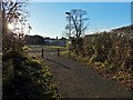
1
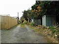
Back lane
The lane runs between Moore Drive and Dennistoun Crescent, giving access to the rear of the properties on both streets. It continues under the railway and joins a track beside the shore.
Image: © Richard Sutcliffe
Taken: 11 Nov 2022
0.02 miles
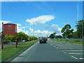
2
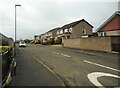
Moore Drive
Seen from the junction with Marmion Avenue.
Image: © Richard Sutcliffe
Taken: 11 Nov 2022
0.02 miles
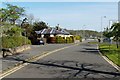
3
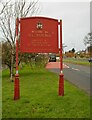
Welcome to Helensburgh
Beside the A814, entering Helensburgh.
WELCOME TO
HELENSBURGH
BIRTHPLACE OF
JOHN LOGIE BAIRD
INVENTOR OF TELEVISION
TWINNED WITH THOUARS - FRANCE
Image: © Richard Sutcliffe
Taken: 11 Nov 2022
0.06 miles
6
Path to Cardross Road
At the time of writing, the map shows this as a road, but it is simply a path that meets the main road near Image
Image: © Lairich Rig
Taken: 23 Nov 2016
0.08 miles
7
Camis Eskan West Lodge
The building just left of centre has the appearance of a lodge. It was the West Lodge associated with Image There were three lodges in all; the Mid Lodge is gone (Image), but the East Lodge survives: Image
As for Camis Eskan West Lodge, the first-edition OS map simply labels it "Lodge". From then until the 1960s, there was another building opposite it, on the other side of the main road (Cardross Road). Confusingly, the 1965 OS map calls the other building "West Lodge", while the one in the present photograph is simply labelled "Lodge". However, the other building had disappeared by 1970.
Image: © Lairich Rig
Taken: 3 May 2012
0.08 miles
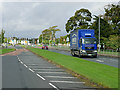
8
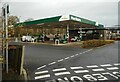
Morrisons Filling Station
Just off the A814, Cardross Road.
Image: © Richard Sutcliffe
Taken: 11 Nov 2022
0.09 miles
9
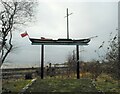
Outline of the Comet
One third scale outline of Henry Bell's Comet - the first commercial steamship in Europe. The outline was erected as part of the bicentenary celebrations to mark the vessel's first voyage in 1812. It is situated beside the railway line behind the Morrisons Filling Station, overlooking the Clyde.
Image: © Richard Sutcliffe
Taken: 11 Nov 2022
0.09 miles
10
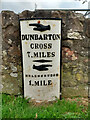
Old milepost
This milepost is on an old section of Cardross Road in Craigendoran, where the A814 has been straightened slightly. One of 4 remaining on the 8 mile stretch of road between Dumbarton and Helensburgh probably set up in the late 19C.
Image: © Hilary Jones
Taken: 11 Aug 2023
0.09 miles