IMAGES TAKEN NEAR TO
Rosneath, HELENSBURGH, G84 0QG
Introduction
This page details the photographs taken nearby to G84 0QG by members of the Geograph project.
The Geograph project started in 2005 with the aim of publishing, organising and preserving representative images for every square kilometre of Great Britain, Ireland and the Isle of Man.

There are currently over 7.5m images from over14,400 individuals and you can help contribute to the project by visiting https://www.geograph.org.uk
Image Map (Loading...)


Getting Data...Please wait
Leaflet Map data © OpenStreetMap
Images are licensed for reuse under creativecommons.org/licenses/by-sa/2.0
Notes
- Clicking on the map will re-center to the selected point.
- The higher the marker number, the further away the image location is from the centre of the postcode.
Image Listing (6 Images Found)
Images are licensed for reuse under creativecommons.org/licenses/by-sa/2.0
Image
Details
Distance
1
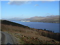
Kilcreggan- Barremman, Gare Loch Forestry Track
View across Gare Loch towards Faslane
Image: © william craig
Taken: 14 Feb 2007
0.09 miles
3
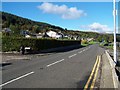
Clynder
Looking up the road to Garelochhead
Image: © william craig
Taken: 13 Oct 2005
0.14 miles
4
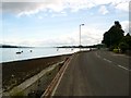
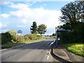
The B833 at Clynder
The Gareloch to the left and Rosneath in the distance.
Image: © Gordon Brown
Taken: 17 Jul 2014
0.14 miles
6
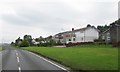
Housing at the village of Clynder on the western shores of the Gare Loch
Image: © James Denham
Taken: 18 Sep 2014
0.15 miles