IMAGES TAKEN NEAR TO
Clynder, HELENSBURGH, G84 0QA
Introduction
This page details the photographs taken nearby to G84 0QA by members of the Geograph project.
The Geograph project started in 2005 with the aim of publishing, organising and preserving representative images for every square kilometre of Great Britain, Ireland and the Isle of Man.

There are currently over 7.5m images from over14,400 individuals and you can help contribute to the project by visiting https://www.geograph.org.uk
Image Map
Images are licensed for reuse under creativecommons.org/licenses/by-sa/2.0
Notes
- Clicking on the map will re-center to the selected point.
- The higher the marker number, the further away the image location is from the centre of the postcode.
Image Listing (7 Images Found)
Images are licensed for reuse under creativecommons.org/licenses/by-sa/2.0
Image
Details
Distance
2
NEW
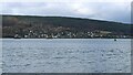
Clynder
Seen from across the Gare Loch from Rhu Point.
Image: © Richard Sutcliffe
Taken: 22 Feb 2025
0.14 miles
3
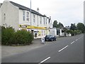
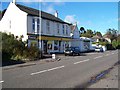
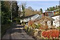
Shop at Clynder
On the shores of the Gare Loch.
Image: © James Denham
Taken: 18 Sep 2014
0.15 miles
6
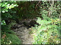
Clynder Burn
Part of the Path from Clynder up to the Quarry and the Forestry Track (see Image).
Image: © william craig
Taken: 29 Aug 2007
0.18 miles
7
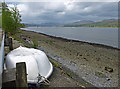
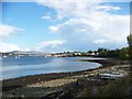
Shoreline Stroul Bay, Rosneath
Looking up Gare Loch to Faslane.
Image: © wfmillar
Taken: 2 May 2009
0.21 miles