IMAGES TAKEN NEAR TO
Cove, HELENSBURGH, G84 0PL
Introduction
This page details the photographs taken nearby to G84 0PL by members of the Geograph project.
The Geograph project started in 2005 with the aim of publishing, organising and preserving representative images for every square kilometre of Great Britain, Ireland and the Isle of Man.

There are currently over 7.5m images from over14,400 individuals and you can help contribute to the project by visiting https://www.geograph.org.uk
Image Map
Images are licensed for reuse under creativecommons.org/licenses/by-sa/2.0
Notes
- Clicking on the map will re-center to the selected point.
- The higher the marker number, the further away the image location is from the centre of the postcode.
Image Listing (52 Images Found)
Images are licensed for reuse under creativecommons.org/licenses/by-sa/2.0
Image
Details
Distance
1
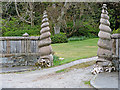
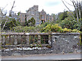
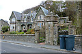
Craigrownie House gateposts
An unusual design, alongside the B833 Shore Road in Cove.
Image: © Thomas Nugent
Taken: 27 Apr 2015
0.06 miles
2
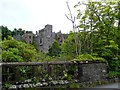
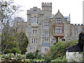
Craigrownie Castle
Built in 1854 and designed by famous Glasgow architect Alexander ‘Greek’ Thomson, the castle has had a varied history. It was built on six storeys for Glasgow business man John McElroy who was an iron founder and railway contractor. It was further expanded and subsequently donated to the Scottish Society for the Mentally Handicapped — now Enable - and became the Stewart Home for children from 1958 until 1983.
It then became an old folks' home, fell into disrepair, then was renovated in the late 1990s. In 2009 it was for sale for a mere £795,000.
Image: © Gordon Brown
Taken: 17 Jul 2014
0.06 miles
3
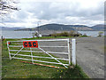
Cove Sailing Club
On Shore Road and Loch Long.
Image: © Thomas Nugent
Taken: 27 Apr 2015
0.07 miles
4
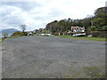
Cove Sailing Club
The boatyard, alongside the B833 Shore Road.
Image: © Thomas Nugent
Taken: 27 Apr 2015
0.07 miles
5
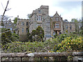
Craigrownie Castle
A Category B Listed building http://data.historic-scotland.gov.uk/pls/htmldb/f?p=2200:15:0::::BUILDING:43473 by Alexander "Greek" Thomson in 1850.
Image: © Thomas Nugent
Taken: 27 Apr 2015
0.07 miles
6
Craigrownie Castle
A Category B Listed building http://data.historic-scotland.gov.uk/pls/htmldb/f?p=2200:15:0::::BUILDING:43473 by Alexander "Greek" Thomson in 1850.
Image: © Thomas Nugent
Taken: 27 Apr 2015
0.07 miles
7
Craigrownie Castle
A Category B Listed building http://data.historic-scotland.gov.uk/pls/htmldb/f?p=2200:15:0::::BUILDING:43473 by Alexander "Greek" Thomson in 1850.
Image: © Thomas Nugent
Taken: 27 Apr 2015
0.07 miles
8
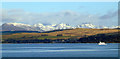
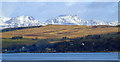
Rosneath Peninsula from Gourock
Cove is in the centre. The vessel is the passenger ferry Ali Cat which runs between Gourock and Dunoon. Viewed from Cloch Road.
Image: © Thomas Nugent
Taken: 19 Feb 2012
0.08 miles
9
Cove from Gourock
Cove Sailing Club is in the centre. Viewed from Cloch Road.
Image: © Thomas Nugent
Taken: 19 Feb 2012
0.08 miles
10
Craigoulet West and Craigoulet East
The gateway in the foreground led to Baron Cliff house which was demolished in 1980. The gateway is Category C Listed http://data.historic-scotland.gov.uk/pls/htmldb/f?p=2200:15:0::::BUILDING:43415 .
Graigoulet West and East in the background are Category B Listed http://data.historic-scotland.gov.uk/pls/htmldb/f?p=2200:15:0::::BUILDING:43431 .
Image: © Thomas Nugent
Taken: 27 Apr 2015
0.08 miles