IMAGES TAKEN NEAR TO
Cove, HELENSBURGH, G84 0PH
Introduction
This page details the photographs taken nearby to G84 0PH by members of the Geograph project.
The Geograph project started in 2005 with the aim of publishing, organising and preserving representative images for every square kilometre of Great Britain, Ireland and the Isle of Man.

There are currently over 7.5m images from over14,400 individuals and you can help contribute to the project by visiting https://www.geograph.org.uk
Image Map
Images are licensed for reuse under creativecommons.org/licenses/by-sa/2.0
Notes
- Clicking on the map will re-center to the selected point.
- The higher the marker number, the further away the image location is from the centre of the postcode.
Image Listing (6 Images Found)
Images are licensed for reuse under creativecommons.org/licenses/by-sa/2.0
Image
Details
Distance
1
Overturned caravan near the Barbour Road
A view looking east from the Barbour Road. I assume the caravan was blown over in the winter gales.
Image: © Phil Williams
Taken: 28 May 2006
0.08 miles
2
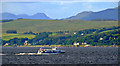
Argyll Flyer passing Cove
One of the vessels on the passengers only route between Gourock Pier and Dunoon Pier.
Image: © Thomas Nugent
Taken: 14 Jul 2012
0.13 miles
3
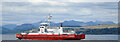
Ferry Sound of Soay in the Firth of Clyde
Western Ferries vessel just departed McInroy's Point, with Cove and the Arrochar Alps beyond.
Image: © Thomas Nugent
Taken: 12 Jul 2024
0.13 miles
4
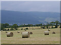
Bales above Kilcreggan
A view across a baled field at the intersection of School Road and Barbour Road, above Kilcreggan.
This photograph was taken during the Coronavirus (COVID-19) pandemic of 2020/21.
Image: © James T M Towill
Taken: 3 Jul 2021
0.21 miles
5
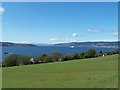
Kilcreggan, view from Barbour Road
Looking down the Clyde. Gourock, Dunoon and Arran in the distance
Image: © william craig
Taken: 5 May 2006
0.23 miles
6
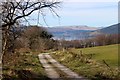
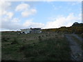
Track above South Ailey
Strone Point lies beyond. Cruach nan Capull is the hilltop on the horizon.
Image: © Alan Reid
Taken: 26 Mar 2017
0.24 miles